Data
- Obtaining
- Supplying
- High-Frequency
- Bottom Pressure Records
- Other Long Records
- GLOSS/ODINAFRICA Calibration Data
Donate
Donate to PSMSL
Data Notes
- Individual Station Data and Plot Notes
- Referencing the Data Set
- PSMSL Help File
- 2010 Changes to the PSMSL Data Files
Extracted from Database
20 Jul 2026
Station Information
| Station ID: | 1160 |
| Latitude: | -13.860056 |
| Longitude: | 136.415583 |
| Coastline code: | 680 |
| Station code: | 15 |
| Country: | AUSTRALIA |
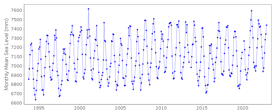
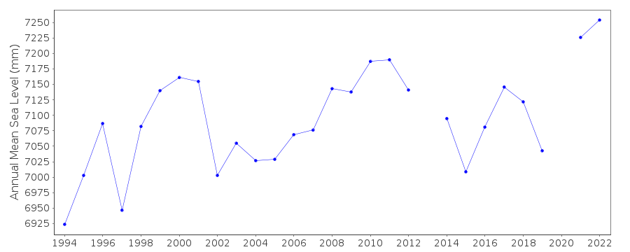
| Time span of RLR data: | 1993 – 2022 |
| RLR completeness (%): | 96 |
| Time span of metric data: | 1966 – 2022 |
| Metric completeness (%): | 72 |
| Date of last update: | 27 Feb 2023 |
| Green Arrow: | Current Station |
| Yellow Marker: | Neighbouring RLR Station |
| Red Marker: | Neighbouring Metric Station |
Please note: In many cases, the station position in our database is accurate to only one minute. Thus, the tide gauge may not appear to be on the coast.
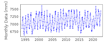
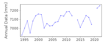
Tide Gauge Data
Additional Data Sources (guide to additional data sources)
Nearby Real Time Stations from VLIZ: grooResearch Quality Data from UHSLC station 145: hourly and daily
Station Documentation
Link to RLR information.Documentation added 1995-05-02
Station density along some sections of the Australian coast has meant that station codes 601 onwards have been re-ordered compared to those in earlier versions of the PSMSL data set.Documentation added 1996-03-28
Revised data received fro the National Tidal Centre, Bureau of Meteorology, South Australia. SEAFRAME station installed 25/09/1993Documentation added 2000-04-10
This is a "baseline station" of the Australian National Tidal Facility.Documentation added 2000-04-10
Millner Bay (Gr.Ey.)680/015 RLR(2000) is 12.61m below BM F159Documentation added 2000-04-10
Millner Bay is also called Groote Eylandt.Documentation added 2011-10-27
Using metadata from the National Tidal Centre, Australia the RLR diagram has been revised. Primary benchmark BM 4567 SEAFRAME benchmark is 6.864m relative to datum Lowest Astronomical Tide (LAT). RLR factor is 5.9m.Data Authority
National Tidal CentreBureau of Meteorology
PO Box 421
Kent Town 5071
South Australia
Documentation added 2010-08-12
Formerly known as the National Tidal Facility

![]()
![]()
![]()
