Data
- Obtaining
- Supplying
- High-Frequency
- Bottom Pressure Records
- Other Long Records
- GLOSS/ODINAFRICA Calibration Data
Donate
Donate to PSMSL
Data Notes
- Individual Station Data and Plot Notes
- Referencing the Data Set
- PSMSL Help File
- 2010 Changes to the PSMSL Data Files
Extracted from Database
13 Jul 2026
Station Information
| Station ID: | 1214 |
| Latitude: | 51.211139 |
| Longitude: | -4.112389 |
| Coastline code: | 170 |
| Station code: | 166 |
| Country: | UNITED KINGDOM |
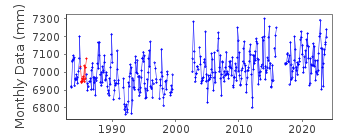
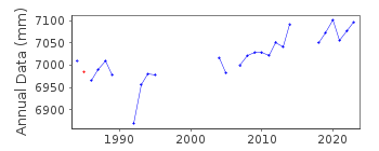
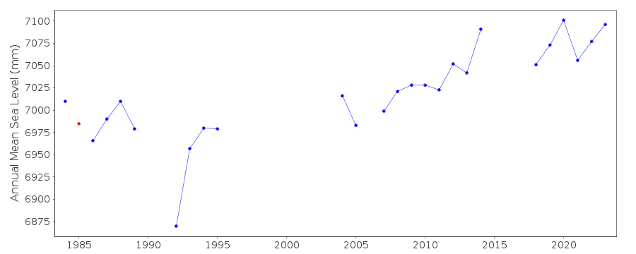
| Time span of RLR data: | 1983 – 2025 |
| RLR completeness (%): | 80 |
| Time span of metric data: | 1968 – 2025 |
| Metric completeness (%): | 69 |
| Date of last update: | 19 Feb 2026 |
| Green Arrow: | Current Station |
| Yellow Marker: | Neighbouring RLR Station |
| Red Marker: | Neighbouring Metric Station |
Please note: In many cases, the station position in our database is accurate to only one minute. Thus, the tide gauge may not appear to be on the coast.
Tide Gauge Data
Additional Data Sources (guide to additional data sources)
Nearby Real Time Stations from VLIZ: ilfaStation Documentation
Link to RLR information.Documentation added 1991-06-11
Ilfracombe 170/166 RLR(1988) is 14.4m below TGBM SS5263 4791Documentation added 1993-07-12
Ilfracombe 170/166 RLR(1988) is 14.4m below TGBM SS5263 4791Documentation added 1994-09-21
A Lea gauge was installed in January 1968, replaced by an Ott inMarch 1973 (both stilling wells), replaced by an "A Class" bubbler
in June 1983.
Documentation added 1994-09-22
1985: pressure point outlet blocked -possible datum error, until November
Documentation added 2001-01-02
Recent work on vertical land movements in the UK can be found fromthe University of Nottingham web site:
http://ukcogr.iessg.nottingham.ac.uk/~eosi/
Documentation added 2009-01-28
Treat data 2002 onwards as suspectDocumentation added 2014-07-03
TGI visited the site on 07.02.2013 for general maitenance and change the compressor. Some low waters were flagged.Documentation added 2015-06-02
During 2014 the values appeared low on the rising tide at the beginning and end of the year. TGI were at site 29.01.14 for General maintenance and to change the compressor.Data Authority
Environment AgencyHorizon House
Deanery Road
BS1 5AH
Bristol

![]()
![]()
![]()
