Data
- Obtaining
- Supplying
- High-Frequency
- Bottom Pressure Records
- Other Long Records
- GLOSS/ODINAFRICA Calibration Data
Donate
Donate to PSMSL
Data Notes
- Individual Station Data and Plot Notes
- Referencing the Data Set
- PSMSL Help File
- 2010 Changes to the PSMSL Data Files
Extracted from Database
13 Jul 2026
Station Information
| Station ID: | 1217 |
| Latitude: | 7.1 |
| Longitude: | 171.366667 |
| GLOSS ID: | 112 |
| Coastline code: | 720 |
| Station code: | 16 |
| Country: | MARSHALL ISLANDS |
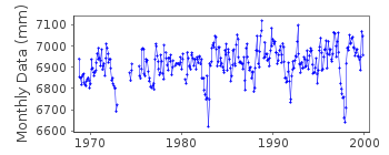
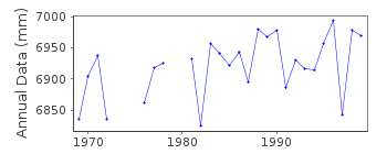
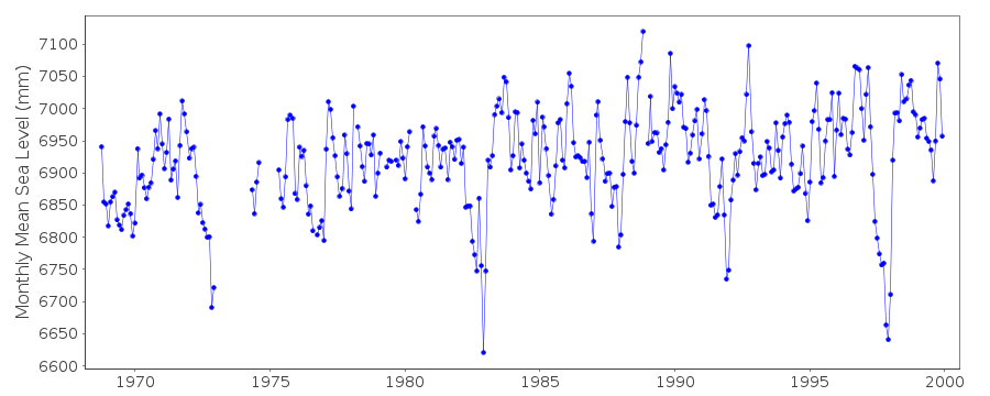
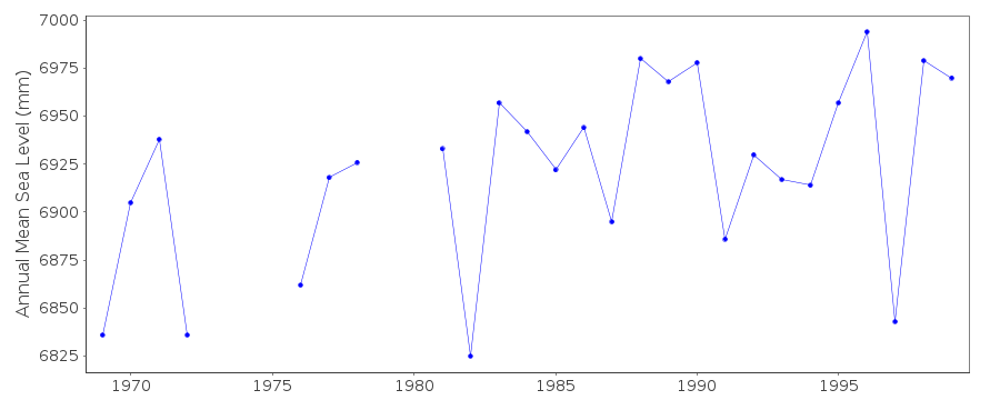
| Time span of data: | 1968 – 1999 |
| Completeness (%): | 89 |
| Link to ellipsoid: | Available |
| Date of last update: | 21 Mar 2001 |
| Green Arrow: | Current Station |
| Yellow Marker: | Neighbouring RLR Station |
| Red Marker: | Neighbouring Metric Station |
Please note: In many cases, the station position in our database is accurate to only one minute. Thus, the tide gauge may not appear to be on the coast.
Tide Gauge Data
Additional Data Sources (guide to additional data sources)
Nearby GNSS Stations from SONEL: MAJUNearby Real Time Stations from VLIZ: marsh
Fast Delivery Data from UHSLC station 5: hourly and daily
Research Quality Data from UHSLC station 5: hourly and daily
Station Documentation
Link to RLR information.Documentation added 1991-06-11
Majuro 720/016 RLR(1983) is 8.4m below BMUGS#1Documentation added 1992-10-27
LOCATION OF STATION CHANGED IN DECEMBER 1987Documentation added 1996-10-07
station not linked geodetically to Majuro A primary gauge 1974-90: Leupold and Stevens Analog-to-Digital Recorder (ADR)primary gauge 1991- : Handar Encoder (ENC)Documentation added 1999-11-15
data for 1968-73 and 1997 revised in December 1999Documentation added 2018-06-14
Data for 2000 and 2001 have been removed. These data were recorded by the Australian National Tidal Centre's gauge (ID 1838) but incorrectly attached to this recordData Authority
University of Hawaii Sea Level CenterDepartment of Oceanography Division of Natural Sciences
1000 Pope Road
Honolulu
Hawaii 96822

![]()
![]()
![]()
