Data
- Obtaining
- Supplying
- High-Frequency
- Bottom Pressure Records
- Other Long Records
- GLOSS/ODINAFRICA Calibration Data
Donate
Donate to PSMSL
Data Notes
- Individual Station Data and Plot Notes
- Referencing the Data Set
- PSMSL Help File
- 2010 Changes to the PSMSL Data Files
Extracted from Database
13 Jul 2026
Station Information
| Station ID: | 1253 |
| Latitude: | -23.122268 |
| Longitude: | -134.966749 |
| GLOSS ID: | 138 |
| Coastline code: | 808 |
| Station code: | 1 |
| Country: | FRENCH POLYNESIA |
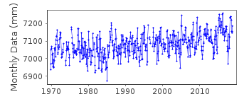
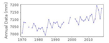
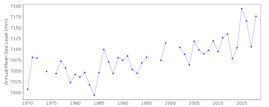
| Time span of data: | 1969 – 2018 |
| Completeness (%): | 94 |
| Link to ellipsoid: | Available |
| Date of last update: | 28 Jan 2020 |
| Green Arrow: | Current Station |
| Yellow Marker: | Neighbouring RLR Station |
| Red Marker: | Neighbouring Metric Station |
Please note: In many cases, the station position in our database is accurate to only one minute. Thus, the tide gauge may not appear to be on the coast.
Tide Gauge Data
Additional Data Sources (guide to additional data sources)
Nearby GNSS Stations from SONEL: RKTG, GAMBNearby Real Time Stations from VLIZ: gamb
Fast Delivery Data from UHSLC station 16: hourly and daily
Research Quality Data from UHSLC station 16: hourly and daily
Station Documentation
Link to RLR information.Documentation added 1991-06-11
Rikitea 808/001 RLR(1983) is 8.8m below BM#3Documentation added 1993-11-11
1969-JUNE 1975 supplied by SHOMDocumentation added 1996-10-08
Instrument type: Bristol Bubbler (BUB) (1969-6/1975); Fischer and Porter Analog-to-Digital Recorder (ADR) (6/1975- )Documentation added 2013-10-14
Complete dataset Oct. 1969 to April 2012 downloaded onto the database from UHSLCDocumentation added 2014-02-27
SHOM has confirmed that the current tide gauge at Rikitea belongs to UHSLC. However, SHOM work closely with UHSLC to maintain and control the instrumentation. SHOM has also recently installed a tide gauge which, longterm will replace the UHSLC gauge.Documentation added 2015-10-28
Using updated JASL data the complete dataset has been reloaded. Using information from the UH levelling sheet benchmark BM 1 stable primary benchmark since 2001 has been added to the RLR diagram. BM 1 is 1.913m above the datum.Data Authority
University of Hawaii Sea Level CenterDepartment of Oceanography Division of Natural Sciences
1000 Pope Road
Honolulu
Hawaii 96822

![]()
![]()
![]()
