Data
- Obtaining
- Supplying
- High-Frequency
- Bottom Pressure Records
- Other Long Records
- GLOSS/ODINAFRICA Calibration Data
Donate
Donate to PSMSL
Data Notes
- Individual Station Data and Plot Notes
- Referencing the Data Set
- PSMSL Help File
- 2010 Changes to the PSMSL Data Files
Extracted from Database
20 Jul 2026
Station Information
| Station ID: | 1277 |
| Latitude: | -3.266667 |
| Longitude: | -80 |
| Coastline code: | 845 |
| Station code: | 41 |
| Country: | ECUADOR |
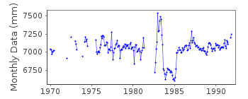
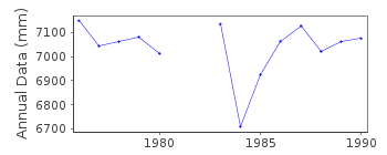
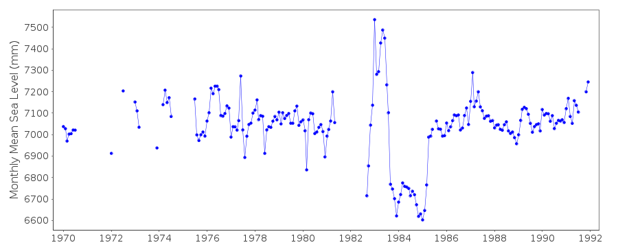
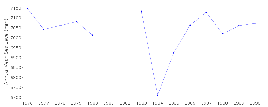
| Time span of data: | 1970 – 1991 |
| Completeness (%): | 75 |
| Date of last update: | 16 Jun 1992 |
| Green Arrow: | Current Station |
| Yellow Marker: | Neighbouring RLR Station |
| Red Marker: | Neighbouring Metric Station |
Please note: In many cases, the station position in our database is accurate to only one minute. Thus, the tide gauge may not appear to be on the coast.
Tide Gauge Data
Additional Data Sources (guide to additional data sources)
Nearby Real Time Stations from VLIZ: pbolStation Documentation
Link to RLR information.Documentation added 1991-06-11
Puerto Bolivar 845/041 RLR(1988) is 8.9m below BM4Documentation added 1993-07-12
Puerto Bolivar 845/041 RLR(1988) is 8.9m below BM4Documentation added 2012-10-04
This is now a historic station last data 1991.Data Authority
Oceanographic Institute of the NavyAv. July 25 Via Puerto Maritime
Naval Base South
Guayaquil

![]()
![]()
![]()
