Data
- Obtaining
- Supplying
- High-Frequency
- Bottom Pressure Records
- Other Long Records
- GLOSS/ODINAFRICA Calibration Data
Donate
Donate to PSMSL
Data Notes
- Individual Station Data and Plot Notes
- Referencing the Data Set
- PSMSL Help File
- 2010 Changes to the PSMSL Data Files
Extracted from Database
13 Jul 2026
Station Information
| Station ID: | 13 |
| Latitude: | 53.958056 |
| Longitude: | 10.872222 |
| Coastline code: | 125 |
| Station code: | 1 |
| Country: | GERMANY |
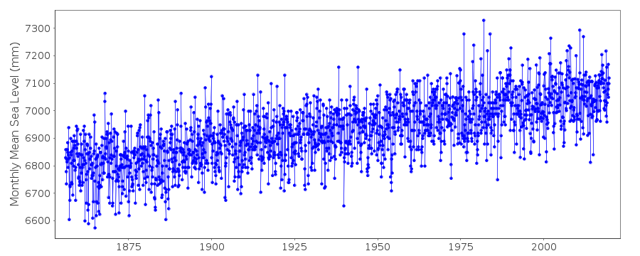
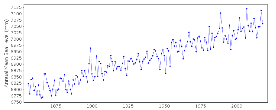
| Time span of data: | 1856 – 2025 |
| Completeness (%): | 100 |
| Date of last update: | 07 Nov 2025 |
| Green Arrow: | Current Station |
| Yellow Marker: | Neighbouring RLR Station |
| Red Marker: | Neighbouring Metric Station |
Please note: In many cases, the station position in our database is accurate to only one minute. Thus, the tide gauge may not appear to be on the coast.
Tide Gauge Data
Station Documentation
Link to RLR information.Documentation added 1994-08-22
Travemunde Metric data measured to datum NN-5000mm where NN=Normal Null.Data 1856-1980 taken from the BFG (Authority 15). Later data were taken
from the report by J.Jensen and A.Toppe in 1986:
Deutsche Gewasserkundliche Mitteilungen, 30(4), 99-107.
Documentation added 1994-08-22
The Jensen and Toppe report includes also values for 1826 onwards.For 1856-1980, the BFG and J+T values differ by only small amounts in
most years although there are large departures in others. At present we
take the BFG values as "official", although see the Jensen and Toppe
paper for a considerable amount of background information.
Documentation added 2002-01-23
Travemuende data up to 1992 supplied by Bundesanstalt fur Gewasserkunde,Koblenz (acode=15). Data 1993- supplied by Bundesamt fur Seeschiffahrt
und Hydrographie (BSH), Hamburg (auth=16).
Documentation added 2010-08-09
The data for Travemunde was measured to Normal Null which is a German datumrelated to levels at Potsdam near Berlin. It is similar to ODN in the UK or the
NAP in Holland. It is unusual therefore that the station has been made RLR as it
'breaks the rules' of RLR. Data 2000 onwards refers to TGZ.
Data Authority
Bundesamt fur Seeschifffahrt und Hydrographie HamburgBernhard-Nocht-Strasse 78
20359 Hamburg
Documentation added 1993-10-05
FORMERLY THE DEUTSCHES HYDROGRAPHISCHES INSTITUT

![]()
![]()
![]()
