Data
- Obtaining
- Supplying
- High-Frequency
- Bottom Pressure Records
- Other Long Records
- GLOSS/ODINAFRICA Calibration Data
Donate
Donate to PSMSL
Data Notes
- Individual Station Data and Plot Notes
- Referencing the Data Set
- PSMSL Help File
- 2010 Changes to the PSMSL Data Files
Extracted from Database
13 Jul 2026
Station Information
| Station ID: | 1328 |
| Latitude: | -20.587972 |
| Longitude: | 117.186028 |
| Coastline code: | 680 |
| Station code: | 491 |
| Country: | AUSTRALIA |
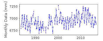
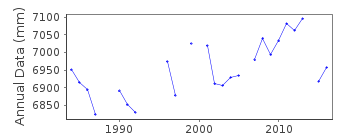
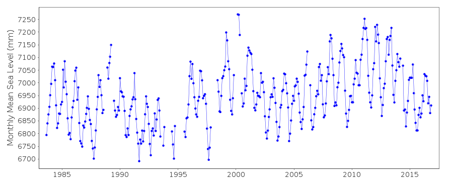
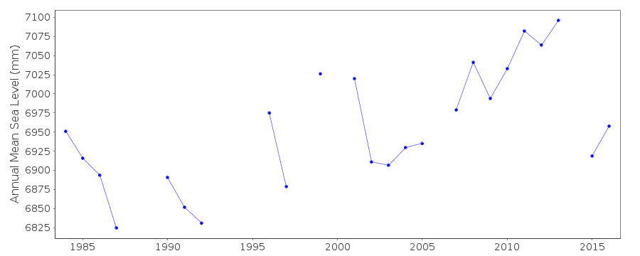
| Time span of RLR data: | 1983 – 2016 |
| RLR completeness (%): | 89 |
| Time span of metric data: | 1972 – 2016 |
| Metric completeness (%): | 67 |
| Date of last update: | 02 Oct 2018 |
| Green Arrow: | Current Station |
| Yellow Marker: | Neighbouring RLR Station |
| Red Marker: | Neighbouring Metric Station |
Please note: In many cases, the station position in our database is accurate to only one minute. Thus, the tide gauge may not appear to be on the coast.
Tide Gauge Data
Station Documentation
Link to RLR information.Documentation added 1995-05-02
Station density along some sections of the Australian coast has meant that station codes 601 onwards have been re-ordered compared to those in earlier versions of the PSMSL data set.Documentation added 1996-05-20
Revised data for 1972-1986 received from the National Tidal Centre, Bureau of Meteorology, South AustraliaDocumentation added 2010-08-23
Supplier has confirmed that for data from September 1983, vertical datum is LAT, and primary benchmark B923 is 12.929m above LAT. RLR (2008) defined as 16.6m below B923Documentation added 2021-02-04
Last data for this station is currently November 2016.Data Authority
National Tidal CentreBureau of Meteorology
PO Box 421
Kent Town 5071
South Australia
Documentation added 2010-08-12
Formerly known as the National Tidal Facility

![]()
![]()
![]()
