Data
- Obtaining
- Supplying
- High-Frequency
- Bottom Pressure Records
- Other Long Records
- GLOSS/ODINAFRICA Calibration Data
Donate
Donate to PSMSL
Data Notes
- Individual Station Data and Plot Notes
- Referencing the Data Set
- PSMSL Help File
- 2010 Changes to the PSMSL Data Files
Extracted from Database
20 Jul 2026
Station Information
| Station ID: | 133 |
| Latitude: | 32.428611 |
| Longitude: | 131.669444 |
| Coastline code: | 645 |
| Station code: | 11 |
| Country: | JAPAN |
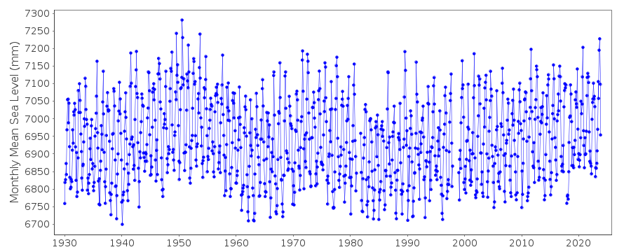
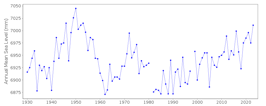
| Time span of RLR data: | 1930 – 2025 |
| RLR completeness (%): | 98 |
| Time span of metric data: | 1900 – 2025 |
| Metric completeness (%): | 98 |
| Link to ellipsoid: | Available |
| Date of last update: | 01 Apr 2026 |
| Green Arrow: | Current Station |
| Yellow Marker: | Neighbouring RLR Station |
| Red Marker: | Neighbouring Metric Station |
Please note: In many cases, the station position in our database is accurate to only one minute. Thus, the tide gauge may not appear to be on the coast.
Tide Gauge Data
Additional Data Sources (guide to additional data sources)
Nearby GNSS Stations from SONEL: P122Research Quality Data from UHSLC station 358: hourly and daily
Station Documentation
Link to RLR information.Documentation - date unknown
1980 DATA SUSPECT - CONDUCTING TUBE IN BAD CONDITIONDocumentation added 1991-06-11
Hosojima 645/011 RLR(1974) is 9.4m below BM Attach-4Documentation added 2011-02-22
Previously data points for December 1979 - December 1980 had been flagged.However when the station was buddy checked with nearby station Aburatsu this period of the sea level profile shows the same pattern. Flag points were therefore removed. The profiles appear to separeate more during the 1990's onwards.Documentation added 2012-02-21
A massive earthquake magnitude 9.0 ocurred at 14:46 JST (05:46 UTC) on Friday 11th March 2011 with the epicenter approx. 70km east of the Oshika Peninsula of Tohoku. It was the most powerful known earthquake to hit Japan. The earthquake triggered a tsunami with waves of up to 40.5m travelling up to 10km inland.Documentation added 2014-03-13
The GPS benchmark information has been downloaded from the SONEL website. GPS benchmark is P122 13.797m above RLR.Data Authority
Geographical Survey InstituteKitasato -1
Tsukuba-shi
Ibaraki-ken 305

![]()
![]()
![]()
