Data
- Obtaining
- Supplying
- High-Frequency
- Bottom Pressure Records
- Other Long Records
- GLOSS/ODINAFRICA Calibration Data
Donate
Donate to PSMSL
Data Notes
- Individual Station Data and Plot Notes
- Referencing the Data Set
- PSMSL Help File
- 2010 Changes to the PSMSL Data Files
Extracted from Database
20 Jul 2026
WARNING: QCFLAG EXISTS. PLEASE READ THE DOCUMENTATION.
Station Information
| Station ID: | 1345 |
| Latitude: | 37.83055556 |
| Longitude: | 140.96166667 |
| Coastline code: | 642 |
| Station code: | 36 |
| Country: | JAPAN |
| Time span of RLR data: | 1973 – 2025 |
| RLR completeness (%): | 88 |
| Time span of metric data: | 1973 – 2025 |
| Metric completeness (%): | 96 |
| Link to ellipsoid: | Available |
| Date of last update: | 07 Apr 2026 |
| Green Arrow: | Current Station |
| Yellow Marker: | Neighbouring RLR Station |
| Red Marker: | Neighbouring Metric Station |
Please note: In many cases, the station position in our database is accurate to only one minute. Thus, the tide gauge may not appear to be on the coast.
Tide Gauge Data
Additional Data Sources (guide to additional data sources)
Nearby GNSS Stations from SONEL: P125, P106Station Documentation
Link to RLR information.Documentation added 1991-06-11
Soma 642/036 RLR(1974) is 11.0m below BM Attach-27Documentation added 2009-11-17
The relevant authority for this station is the Geographical Survey Institute. For some reason the data for 1998 was not downloaded from this authority. Data downloaded and entered 17.11.09.Documentation added 2012-02-22
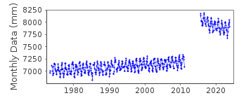
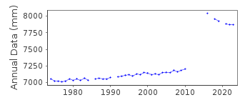
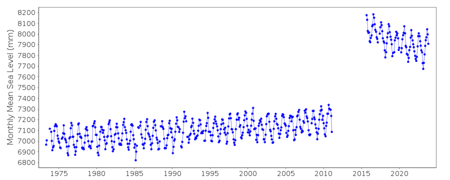
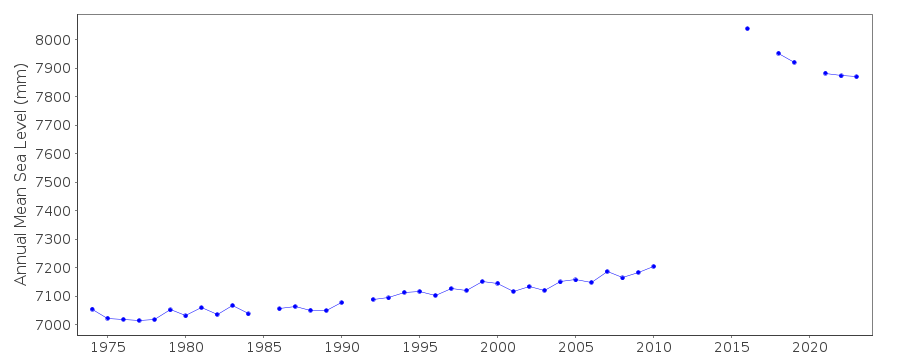
A massive earthquake of magnitude 9.0 occurred at 14.46 JST (05.46 UTC) on Friday 11th March 2011 with the epicentre situated approx. 70km east of the Oshika Peninsula of Tohoku. It was the largest earthquake to strike Japan and triggered a tsunami with waves of up to 40.5m and travelling inland up to 10km.Documentation added 2014-03-13
The GPS benchmark information has been downloaded from the SONEL website. GPS benchmark P106 is 14.116m above RLR.Documentation added 2022-04-05
Following review of data affected by the Tōhoku earthquake of 2011, all data has been flagged as good as GSI have recommenced levelling at the site. The station flag has been set to indicate the record needs to be treated with care, but the data appears to accurately reflect the earthquake's ongoing effect on local relative sea level.Documentation added 2022-04-26
Documentation from the GSI confirms this installation was destroyed in the tsunami following the Tōhoku earthquake in March 2011. A temporary gauge was set up in June 2011, and a new permanent installation began operating in September 2015. Data from the temporary site have not been connected to the primary benchmark through levelling, so this period is not included in the RLR dataset.Data Authority
Geographical Survey InstituteKitasato -1
Tsukuba-shi
Ibaraki-ken 305

![]()
![]()
![]()
