Data
- Obtaining
- Supplying
- High-Frequency
- Bottom Pressure Records
- Other Long Records
- GLOSS/ODINAFRICA Calibration Data
Donate
Donate to PSMSL
Data Notes
- Individual Station Data and Plot Notes
- Referencing the Data Set
- PSMSL Help File
- 2010 Changes to the PSMSL Data Files
Extracted from Database
20 Jul 2026
Station Information
| Station ID: | 1352 |
| Latitude: | 36.605 |
| Longitude: | -121.886667 |
| Coastline code: | 823 |
| Station code: | 36 |
| Country: | UNITED STATES |
| Time span of data: | 1973 – 2025 |
| Completeness (%): | 98 |
| Date of last update: | 28 Jan 2026 |
| Green Arrow: | Current Station |
| Yellow Marker: | Neighbouring RLR Station |
| Red Marker: | Neighbouring Metric Station |
Please note: In many cases, the station position in our database is accurate to only one minute. Thus, the tide gauge may not appear to be on the coast.
Tide Gauge Data
Additional Data Sources (guide to additional data sources)
Nearby GNSS Stations from SONEL: P231Nearby Real Time Stations from VLIZ: mont, mont2
Research Quality Data from UHSLC station 555: hourly and daily
Station Documentation
Link to RLR information.Documentation added 1991-06-11
Monterey 823/036 RLR(1986) is 10.8m below BM 2 1924Documentation added 2011-12-20
Using NOAA data the RLR diagram has been reviewed. Primary benchmark remains 2 1924 5.669m above gauge datum but has been given its full title as appears on the NOAA website.Documentation added 2012-09-18
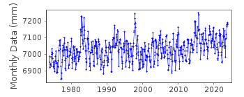
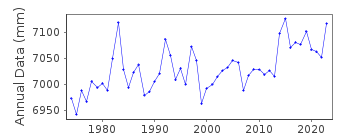
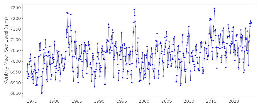
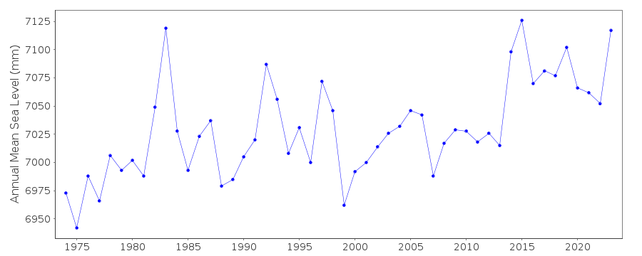
For information: Data values during the early 1980's appear to be particularly high. This phenomenon could be due to the El Nino Southern Oscillation (ENSO)as it is mirrored all along the Californian coast.Data Authority
N.O.A.A. / N.O.S.N/oes33, Ssmc4, Room 6531
1305 East-West Highway
Silver Spring,
MD 20910

![]()
![]()
![]()
