Data
- Obtaining
- Supplying
- High-Frequency
- Bottom Pressure Records
- Other Long Records
- GLOSS/ODINAFRICA Calibration Data
Donate
Donate to PSMSL
Data Notes
- Individual Station Data and Plot Notes
- Referencing the Data Set
- PSMSL Help File
- 2010 Changes to the PSMSL Data Files
Extracted from Database
13 Jul 2026
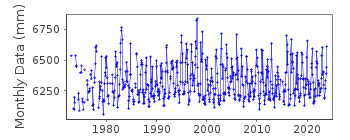
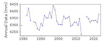
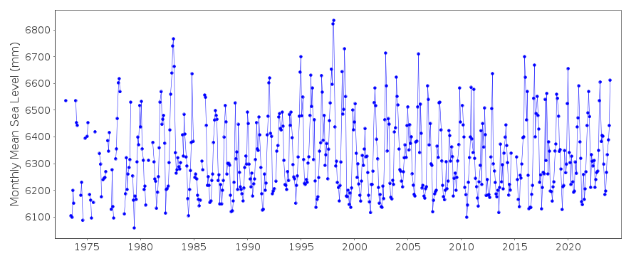
Station Information
| Station ID: | 1354 |
| Latitude: | 46.706667 |
| Longitude: | -123.966667 |
| Coastline code: | 823 |
| Station code: | 9 |
| Country: | UNITED STATES |
| Time span of data: | 1973 – 2025 |
| Completeness (%): | 93 |
| Date of last update: | 28 Jan 2026 |
| Green Arrow: | Current Station |
| Yellow Marker: | Neighbouring RLR Station |
| Red Marker: | Neighbouring Metric Station |
Please note: In many cases, the station position in our database is accurate to only one minute. Thus, the tide gauge may not appear to be on the coast.
Tide Gauge Data
Additional Data Sources (guide to additional data sources)
Research Quality Data from UHSLC station 564: hourly and dailyStation Documentation
Link to RLR information.Documentation added 2000-04-26
Toke Point 823/009 RLR(1999) is 9.579m below Tidal BM 0910 L 1978Documentation added 2012-02-27
Primary benchmark for Toke Point is now BM P 1983 5.406m above TGZ. Previous Primary benchmark Tidal BM 0910 L 1978 6.079m is still listed in the NOAA report but now with a value of 6.058m.Data Authority
N.O.A.A. / N.O.S.N/oes33, Ssmc4, Room 6531
1305 East-West Highway
Silver Spring,
MD 20910

![]()
![]()
![]()
