Data
- Obtaining
- Supplying
- High-Frequency
- Bottom Pressure Records
- Other Long Records
- GLOSS/ODINAFRICA Calibration Data
Donate
Donate to PSMSL
Data Notes
- Individual Station Data and Plot Notes
- Referencing the Data Set
- PSMSL Help File
- 2010 Changes to the PSMSL Data Files
Extracted from Database
20 Jul 2026
Station Information
| Station ID: | 1370 |
| Latitude: | 6.983333 |
| Longitude: | 158.233333 |
| GLOSS ID: | 115 |
| Coastline code: | 710 |
| Station code: | 31 |
| Country: | MICRONESIA, FEDERATED STATES OF |
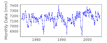
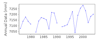
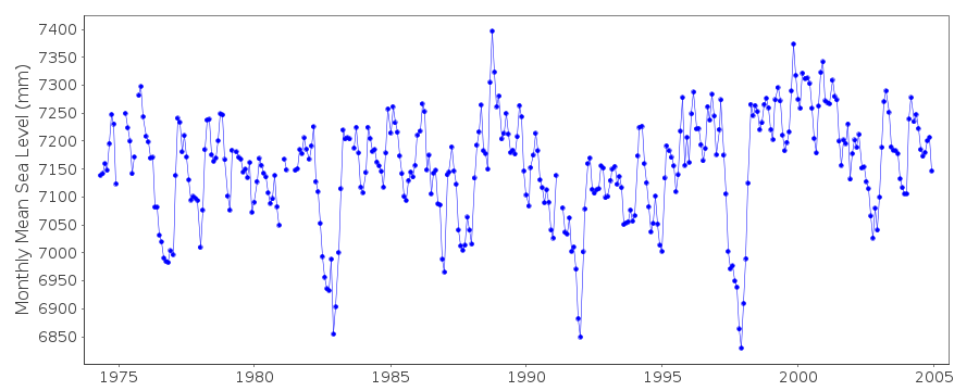
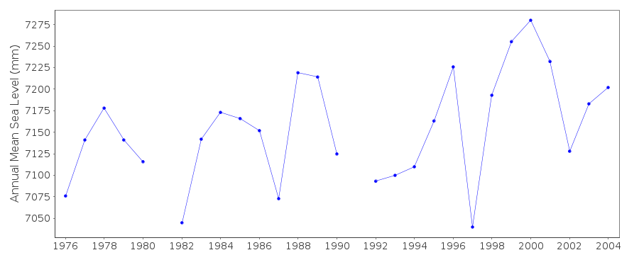
| Time span of data: | 1974 – 2004 |
| Completeness (%): | 96 |
| Link to ellipsoid: | Available |
| Date of last update: | 14 Jun 2018 |
| Green Arrow: | Current Station |
| Yellow Marker: | Neighbouring RLR Station |
| Red Marker: | Neighbouring Metric Station |
Please note: In many cases, the station position in our database is accurate to only one minute. Thus, the tide gauge may not appear to be on the coast.
Tide Gauge Data
Additional Data Sources (guide to additional data sources)
Nearby GNSS Stations from SONEL: POHNNearby Real Time Stations from VLIZ: deke
Fast Delivery Data from UHSLC station 1: hourly and daily
Research Quality Data from UHSLC station 1: hourly and daily
Station Documentation
Link to RLR information.Documentation added 1991-06-11
Pohnpeei 710/031 RLR(1982) is 8.9m below BMUGGS#1Documentation added 1996-10-07
1974-1990 primary gauge=Leupold & Stevens Analog-to-Digital Recorder (ADR)1991- primary gauge=Handar Encoder (ENC)Documentation added 2015-11-04
Complete updated JASL dataset loaded onto the database. UHSLC metadata reports that data 2001-2004 were adjusted by +7mm to link to the zero assigned to the update of 2005-2012 provided in May 2013 by NTC.Documentation added 2015-12-09
Referring to the UH levelling sheet for Pohnpei benchmark USGS1 is confirmed as the Primary Benchmark. However, through successive levellings it is not completely stable. It appears that the RLR diagram was prepared using the 1976/1981 values of 2.479m rounded to 3 decimal places. This agrees with the historic levelling sheet found with the original RLR diagram. Over time the values change from a maximum of 2.4792m in 1976 to a minimum of 2.4725m in 1991. Value for the last levelling exercise in 2004 is 2.4778m.Documentation added 2018-06-14
The update documented on 2015-11-04 was performed incorrectly: the data loaded was from the Australian National Tidal Centre's gauge and should have been loaded to PSMSL ID 1925. Data for 2002-2004 have been replaced with the original data from UHSLC (using their series 001b), data from 2005-2014 have been removed. The gauge was removed in 2004.Data Authority
University of Hawaii Sea Level CenterDepartment of Oceanography Division of Natural Sciences
1000 Pope Road
Honolulu
Hawaii 96822

![]()
![]()
![]()
