Data
- Obtaining
- Supplying
- High-Frequency
- Bottom Pressure Records
- Other Long Records
- GLOSS/ODINAFRICA Calibration Data
Donate
Donate to PSMSL
Data Notes
- Individual Station Data and Plot Notes
- Referencing the Data Set
- PSMSL Help File
- 2010 Changes to the PSMSL Data Files
Extracted from Database
13 Jul 2026
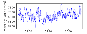
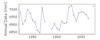
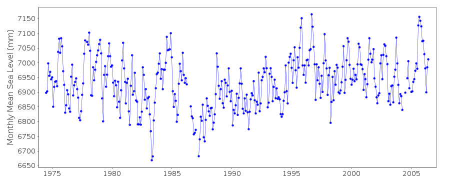
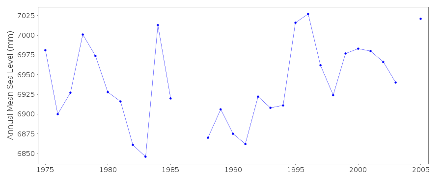
Station Information
| Station ID: | 1372 |
| Latitude: | 23.866667 |
| Longitude: | -166.283333 |
| GLOSS ID: | 107 |
| Coastline code: | 760 |
| Station code: | 16 |
| Country: | UNITED STATES |
| Time span of data: | 1974 – 2006 |
| Completeness (%): | 94 |
| Date of last update: | 14 Oct 2013 |
| Green Arrow: | Current Station |
| Yellow Marker: | Neighbouring RLR Station |
| Red Marker: | Neighbouring Metric Station |
Please note: In many cases, the station position in our database is accurate to only one minute. Thus, the tide gauge may not appear to be on the coast.
Tide Gauge Data
Additional Data Sources (guide to additional data sources)
Nearby GNSS Stations from SONEL: TEPCNearby Real Time Stations from VLIZ: fren
Fast Delivery Data from UHSLC station 14: hourly and daily
Research Quality Data from UHSLC station 14: hourly and daily
Station Documentation
Link to RLR information.Documentation - date unknown
KNOWN AS BOTH FRENCH FRIGATE SHOALS AND TERN ISLANDDocumentation added 1991-06-11
French Frigate Shoal760/016 RLR(1983) is 8.9m below BMUSGS#1Documentation added 1993-07-12
French Frigate Shoal760/016 RLR(1983) is 8.9m below BMUSGS#1Documentation added 1996-10-07
instrument type: Fischer and Porter Analog-to-Digital RecorderDocumentation added 1997-11-13
11 Oct 1996: Handar Encoder installed and became primary gaugeDocumentation added 1998-12-31
data for 1996 revised in December 1998Documentation added 1999-11-15
data for 1997 revised in December 1999Documentation added 2010-11-17
The complete dataset 1974-2004 has been supplied by UHSLC. After checking thesewith existing data values these data have been added to the database. RLR
remains 6.371m.
Documentation added 2012-08-06
When preparing the RLR diagram for inclusion on the PSMSL website it wasdiscovered that the UHSLC dataset does not have an annual mean for 1983.
This was the RLR year on the old RLR diagram. RLR was recalculated using
1984 annual mean. RLR factor is now 6.171m.
Documentation added 2013-10-14
Complete dataset July 1974 to March 2007 downloaded onto database from UHSLCData Authority
University of Hawaii Sea Level CenterDepartment of Oceanography Division of Natural Sciences
1000 Pope Road
Honolulu
Hawaii 96822

![]()
![]()
![]()
