Data
- Obtaining
- Supplying
- High-Frequency
- Bottom Pressure Records
- Other Long Records
- GLOSS/ODINAFRICA Calibration Data
Donate
Donate to PSMSL
Data Notes
- Individual Station Data and Plot Notes
- Referencing the Data Set
- PSMSL Help File
- 2010 Changes to the PSMSL Data Files
Extracted from Database
13 Jul 2026
Station Information
| Station ID: | 1374 |
| Latitude: | -0.533333 |
| Longitude: | 166.9 |
| GLOSS ID: | 114 |
| Coastline code: | 715 |
| Station code: | 1 |
| Country: | NAURU |
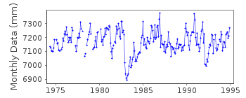
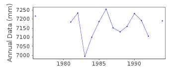
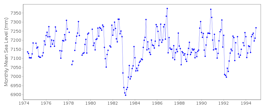
| Time span of data: | 1974 – 1994 |
| Completeness (%): | 91 |
| Link to ellipsoid: | Available |
| Date of last update: | 14 Feb 1996 |
| Green Arrow: | Current Station |
| Yellow Marker: | Neighbouring RLR Station |
| Red Marker: | Neighbouring Metric Station |
Please note: In many cases, the station position in our database is accurate to only one minute. Thus, the tide gauge may not appear to be on the coast.
Tide Gauge Data
Additional Data Sources (guide to additional data sources)
Nearby GNSS Stations from SONEL: NAURNearby Real Time Stations from VLIZ: nauu
Fast Delivery Data from UHSLC station 4: hourly and daily
Research Quality Data from UHSLC station 4: hourly and daily
Station Documentation
Link to RLR information.Documentation added 1991-06-11
Nauru 715/001 RLR(1983) is 9.9m below BM1Documentation added 1996-10-07
May 1974-October 1985: primary gauge=Fischer and Porter October 1985-December 1994: primary gauge=Leupold and StevensDocumentation added 1998-01-12
4 January 1995: Aquatrak acoustic gauge (SEAFRAME) installed by the National Tidal Facility. This is now the primary gauge.Documentation added 2000-04-11
All data up to and including 1998 has been received from the UHSLC so the supplying authority has been changed to UHSLC. From the UH levelling sheet the RLR diagram was produced using the 1983 levelling information. Primary benchmark UH 1 12.791ft(3.899m) above the datum. The value remained the same for the 1986 levelling but became unstable from the 1988 levelling onwards.Data Authority
University of Hawaii Sea Level CenterDepartment of Oceanography Division of Natural Sciences
1000 Pope Road
Honolulu
Hawaii 96822

![]()
![]()
![]()
