Data
- Obtaining
- Supplying
- High-Frequency
- Bottom Pressure Records
- Other Long Records
- GLOSS/ODINAFRICA Calibration Data
Donate
Donate to PSMSL
Data Notes
- Individual Station Data and Plot Notes
- Referencing the Data Set
- PSMSL Help File
- 2010 Changes to the PSMSL Data Files
Extracted from Database
13 Jul 2026
Station Information
| Station ID: | 1397 |
| Latitude: | -17.533081 |
| Longitude: | -149.572724 |
| GLOSS ID: | 140 |
| Coastline code: | 780 |
| Station code: | 11 |
| Country: | FRENCH POLYNESIA |
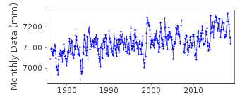
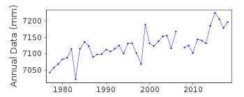
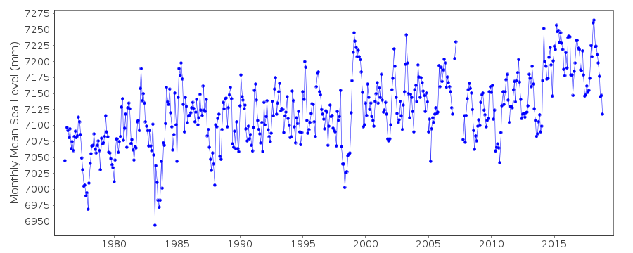
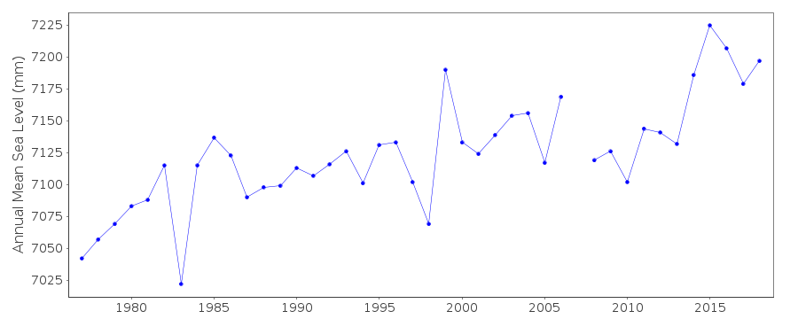
| Time span of data: | 1975 – 2018 |
| Completeness (%): | 97 |
| Link to ellipsoid: | Available |
| Date of last update: | 19 Jun 2025 |
| Green Arrow: | Current Station |
| Yellow Marker: | Neighbouring RLR Station |
| Red Marker: | Neighbouring Metric Station |
Please note: In many cases, the station position in our database is accurate to only one minute. Thus, the tide gauge may not appear to be on the coast.
Tide Gauge Data
Additional Data Sources (guide to additional data sources)
Nearby GNSS Stations from SONEL: THTG, PAPE, FAA1, TAH1, TAH2, THTINearby Real Time Stations from VLIZ: pape2, pape
Fast Delivery Data from UHSLC station 15: hourly and daily
Research Quality Data from UHSLC station 590: hourly and daily
Research Quality Data from UHSLC station 15: hourly and daily
Station Documentation
Link to RLR information.Documentation added 1991-06-11
Papeete 780/011 RLR(1983) is 8.1m below BMNU-2Documentation added 1996-04-23
prior to July 1992 data from acode 97 all data received from TOGA SLCDocumentation added 1996-10-08
instrument type:1975-6/1992: float and well gauge Fischer and Porter Analog-to-Digital Recorder; 7/1992- Aquatrak acoustic gauge, NOAA Next Generation Water Level Measuring System(NGWLMS)Documentation added 2010-11-17
Data up to 1996 was originally in Hawaii format with an RLR value of 5.956m. 1997 was missing and data for 1998-2002 was obtained from NOAA these numbers were very different with a RLR of -5.731m. The complete dataset 1975-2009 has been supplied by UHSLC in Hawaii format. After comparing these with existing data values these has been loaded onto the database. RLR value is once again 5.956m.Documentation added 2012-08-07
Following the receipt of the complete dataset 1975-2009 from Hawaii the NOS datum 11.687m below the Datum 1975 onwards has been included in the RLR diagram for information only.Documentation added 2014-02-26
Following information received from SHOM regarding the Papeete gauge it was realised that id. 1397 should include the complete UHSLC dataset 1975-2012. This dataset has now been loaded. SHOM confirmed that although on French Polynesia the tide gauge at Papeete belongs to UHSLC since its installation in 1975. However, SHOM has an office close to the tide gauge so work closely with UHSLC to maintain and control the instrumentation.Documentation added 2015-09-23
Using information from the UH levelling sheet previous data for Papeete the PSMSL id. 1260 (1969-1975)has been added to this dataset together with the updated JASL data.Documentation added 2018-10-11
Following correspondence with both SONEL and UHSLC data for Papeete-A PSMSL id. 1260 (1969-1975) has been removed from this dataset. On further investigation it was discovered that at some point in time 850mm had been added to Papeete-ADocumentation added 2025-07-16
Updated the whole dataset to ensure they include all the historical data recovered recently by SHOM and the calculated monthly and annual means match those distributed by SONEL.Data Authority
University of Hawaii Sea Level CenterDepartment of Oceanography Division of Natural Sciences
1000 Pope Road
Honolulu
Hawaii 96822

![]()
![]()
![]()
