Data
- Obtaining
- Supplying
- High-Frequency
- Bottom Pressure Records
- Other Long Records
- GLOSS/ODINAFRICA Calibration Data
Donate
Donate to PSMSL
Data Notes
- Individual Station Data and Plot Notes
- Referencing the Data Set
- PSMSL Help File
- 2010 Changes to the PSMSL Data Files
Extracted from Database
20 Jul 2026
Station Information
| Station ID: | 1406 |
| Latitude: | 22.75 |
| Longitude: | 115.35 |
| Coastline code: | 610 |
| Station code: | 6 |
| Country: | CHINA |
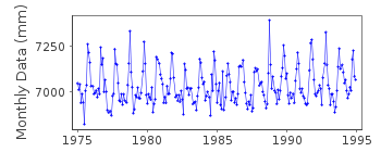
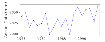
| Time span of RLR data: | 1975 – 1994 |
| RLR completeness (%): | 100 |
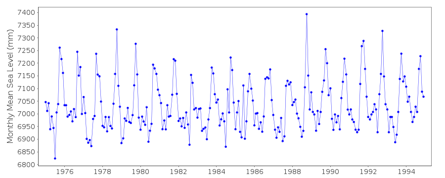
| Time span of metric data: | 1975 – 1997 |
| Metric completeness (%): | 98 |
| Date of last update: | 17 Jan 2012 |
| Green Arrow: | Current Station |
| Yellow Marker: | Neighbouring RLR Station |
| Red Marker: | Neighbouring Metric Station |
Please note: In many cases, the station position in our database is accurate to only one minute. Thus, the tide gauge may not appear to be on the coast.
Tide Gauge Data
Additional Data Sources (guide to additional data sources)
Research Quality Data from UHSLC station 641: hourly and dailyStation Documentation
Link to RLR information.Documentation added 1993-10-19
Shanwei 610/006 RLR(1990) is 9.7m below BMDocumentation added 2012-01-18
Using data from the latest UHSLC JASL cd data for 1995-1997 was extracted andadded to the 'METRIC' dataset. Where the Hawaii data overlapped with that
previously held for this station there were differences of approximately 10mm.
Shanwei is an historic station last data that for 1997 supplied by UHSLC see
above.
Data Authority
National Marine Data and Information Service (NMDIS)No. 93 Liuwei Road
Tianjin 300171

![]()
![]()
![]()
