Data
- Obtaining
- Supplying
- High-Frequency
- Bottom Pressure Records
- Other Long Records
- GLOSS/ODINAFRICA Calibration Data
Donate
Donate to PSMSL
Data Notes
- Individual Station Data and Plot Notes
- Referencing the Data Set
- PSMSL Help File
- 2010 Changes to the PSMSL Data Files
Extracted from Database
13 Jul 2026
Station Information
| Station ID: | 1448 |
| Latitude: | 54.060278 |
| Longitude: | 14.000833 |
| Coastline code: | 120 |
| Station code: | 1 |
| Country: | GERMANY |
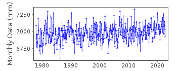
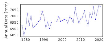
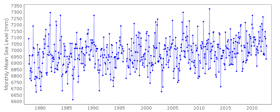
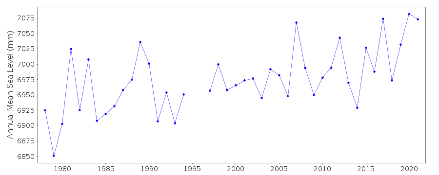
| Time span of data: | 1977 – 2025 |
| Completeness (%): | 97 |
| Date of last update: | 07 Nov 2025 |
| Green Arrow: | Current Station |
| Yellow Marker: | Neighbouring RLR Station |
| Red Marker: | Neighbouring Metric Station |
Please note: In many cases, the station position in our database is accurate to only one minute. Thus, the tide gauge may not appear to be on the coast.
Tide Gauge Data
Station Documentation
Link to RLR information.Documentation added 1992-07-09
GAUGES IN EASTERN GERMANY (WISMAR, WARNEMUNDE, SASSNITZ, KOSEROW) ASOF MARCH 1992 ARE TYPE 'STEREMAT', VERTICAL DRUM, SWIMMER PRINCIPLE,
MEASURES 1:10, CONTINUOUS REGISTRATION ON PAPER CHART. (INFORMATION
FROM L.BALLANI, POTSDAM).
Documentation added 1992-07-09
DATA JANUARY 1974 - OCTOBER 1979 WERE SUMMED FROM 4 VALUES PER DAY AT(01,07,13,19 MEZ) AND NUMBER OF VALUES OVER ONE MONTH AVERAGED.
DATA NOVEMBER 1979 - OCTOBER 1990 OBTAINED FROM ALL HOURLY VALUES IN
THE MONTH. (INFORMATION FROM L.BALLANI MARCH 1992).
Documentation added 2002-01-23
Koserow data up to 1992 supplied by Geoforschungszentrum Potsdam (08).Data 1993- supplied by Bundesamt fur Seeschiffahrt und Hydrographie (BSH),
Hamburg (auth 16).
Documentation added 2010-08-09
The data for Koserow was measured to PN=HN-514cm (HN=zero of official heightsystem)Normal depth of PN=500cm. It is unusual to relate such a station to RLR as
this 'breaks the rules' of RLR. Data now refers to TGZ.
Documentation added 2021-01-20
The pier on which the Koserow tide gauge stood was destroyed on 12th November 2019. From then the gap was infilled from the gauge Greifswalder Oie. Building of a new pier commenced 27th November 2019 with a temporary pressure tube installed.Data Authority
Bundesamt fur Seeschifffahrt und Hydrographie HamburgBernhard-Nocht-Strasse 78
20359 Hamburg
Documentation added 1993-10-05
FORMERLY THE DEUTSCHES HYDROGRAPHISCHES INSTITUT

![]()
![]()
![]()
