Data
- Obtaining
- Supplying
- High-Frequency
- Bottom Pressure Records
- Other Long Records
- GLOSS/ODINAFRICA Calibration Data
Donate
Donate to PSMSL
Data Notes
- Individual Station Data and Plot Notes
- Referencing the Data Set
- PSMSL Help File
- 2010 Changes to the PSMSL Data Files
Extracted from Database
09 Feb 2026
WARNING: QCFLAG EXISTS. PLEASE READ THE DOCUMENTATION.
Station Information
| Station ID: | 145 |
| Latitude: | 14.583333 |
| Longitude: | 120.966667 |
| GLOSS ID: | 73 |
| Coastline code: | 660 |
| Station code: | 11 |
| Country: | PHILIPPINES |
| Time span of data: | 1901 – 2024 |
| Completeness (%): | 85 |
| Link to ellipsoid: | Available |
| Date of last update: | 18 Jun 2025 |
| Green Arrow: | Current Station |
| Yellow Marker: | Neighbouring RLR Station |
| Red Marker: | Neighbouring Metric Station |
Please note: In many cases, the station position in our database is accurate to only one minute. Thus, the tide gauge may not appear to be on the coast.
Tide Gauge Data
Additional Data Sources (guide to additional data sources)
Nearby GNSS Stations from SONEL: PTAG, PTGG, MANL, PIMONearby Real Time Stations from VLIZ: mani
Fast Delivery Data from UHSLC station 370: hourly and daily
Research Quality Data from UHSLC station 370: hourly and daily
Station Documentation
Link to RLR information.Documentation - date unknown
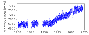
Inccrease in trend in MSL rise suspected to be due to deposition from the river discharges and excessive reclamation although subsidence not totally discarded see letter from coast and Geodetic survey (13/5/1987).Documentation added 1991-06-11
Manila 660/011 RLR(1974) is 9.9m below BM4aDocumentation added 1999-03-30
Gauge type = Ott. Records for Manila started in 1901 with datum of observations TSO 1901 and benchmark 4a 5.342m above the datum. In February 1981 BM 4a was destroyed see letter of 22.01.88. From then onwards BM 4B was used 5.306m above datum. On the sheet accompanying the 1993 data both BM 4B and benchmark GM-1A 6.064m above datum are listed although the main reference remains BM 4B. During 2002 the gauge was moved approximately 1km NNW from the original site,see letter of 21.10.03.Thereafter the reference datum is BM 66 4.509m above datum. The datum remains TSO 1901 throughout the dataset. Gauge type is SUTRONData Authority
National Mapping and Resource Information AuthorityHydrography Department
421 Barraca St,
San Nicolas 1010
Manila


