Data
- Obtaining
- Supplying
- High-Frequency
- Bottom Pressure Records
- Other Long Records
- GLOSS/ODINAFRICA Calibration Data
Donate
Donate to PSMSL
Data Notes
- Individual Station Data and Plot Notes
- Referencing the Data Set
- PSMSL Help File
- 2010 Changes to the PSMSL Data Files
Extracted from Database
20 Jul 2026
Station Information
| Station ID: | 1450 |
| Latitude: | -9.016667 |
| Longitude: | -158.066667 |
| GLOSS ID: | 143 |
| Coastline code: | 775 |
| Station code: | 1 |
| Country: | COOK ISLANDS |
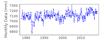
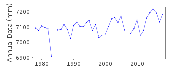
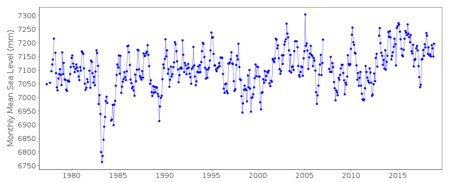
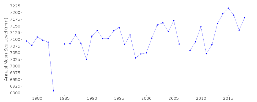
| Time span of data: | 1977 – 2018 |
| Completeness (%): | 95 |
| Date of last update: | 28 Jan 2020 |
| Green Arrow: | Current Station |
| Yellow Marker: | Neighbouring RLR Station |
| Red Marker: | Neighbouring Metric Station |
Please note: In many cases, the station position in our database is accurate to only one minute. Thus, the tide gauge may not appear to be on the coast.
Tide Gauge Data
Additional Data Sources (guide to additional data sources)
Nearby Real Time Stations from VLIZ: penrFast Delivery Data from UHSLC station 24: hourly and daily
Research Quality Data from UHSLC station 24: hourly and daily
Station Documentation
Link to RLR information.Documentation added 1991-10-08
RLR(1989) IS 8.1M BELOW BM 1 8/10/91Documentation added 1996-10-08
Gauge type: (primary,Apr 1977-present) Leupold and Stevens Analog-to-Digital Recorder (ADR); (backup,Jul 1986-present) Handar Encoder (ENC)Primary gauge:ADR:1977-90,ENC:1991-Documentation added 2010-11-17
The complete dataset 1977-Sept. 2010 has been supplied by UHSLC. After checking these with existing data values they have been loaded onto the database. RLR remains 5.940m.Documentation added 2013-10-14
Complete dataset April 1977 to April 2012 downloaded onto the database from UHSLCDocumentation added 2015-11-04
Complete updated JASL dataset loaded onto the database. Pat Caldwells report on the updated data confirms that data for 2007-2012 has been adjusted for a calibration change.Documentation added 2016-01-06
Using information from the UH levelling sheet the RLR diagram has been revised. Value of the Primary benchmarkBM 1 was taken from levelling in 1977 and 1984. The value for BM 1 in subsequent levelling exercises wander slightly. A new primary benchmark BM 6 was installed in March 2000 with a value of 2.1006m. This has remained stable through to the last levelling carried out in 2013. Primary benchmark BM 6 has been added to the RLR diagram.
Data Authority
University of Hawaii Sea Level CenterDepartment of Oceanography Division of Natural Sciences
1000 Pope Road
Honolulu
Hawaii 96822

![]()
![]()
![]()
