Data
- Obtaining
- Supplying
- High-Frequency
- Bottom Pressure Records
- Other Long Records
- GLOSS/ODINAFRICA Calibration Data
Donate
Donate to PSMSL
Data Notes
- Individual Station Data and Plot Notes
- Referencing the Data Set
- PSMSL Help File
- 2010 Changes to the PSMSL Data Files
Extracted from Database
20 Jul 2026
Station Information
| Station ID: | 1452 |
| Latitude: | -8.533333 |
| Longitude: | 179.216667 |
| GLOSS ID: | 121 |
| Coastline code: | 732 |
| Station code: | 11 |
| Country: | TUVALU |
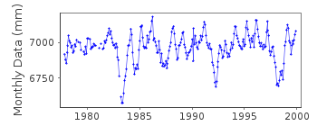
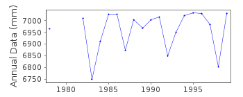
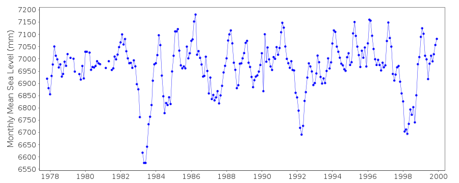
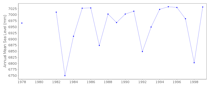
| Time span of data: | 1977 – 1999 |
| Completeness (%): | 92 |
| Date of last update: | 21 Mar 2001 |
| Green Arrow: | Current Station |
| Yellow Marker: | Neighbouring RLR Station |
| Red Marker: | Neighbouring Metric Station |
Please note: In many cases, the station position in our database is accurate to only one minute. Thus, the tide gauge may not appear to be on the coast.
Tide Gauge Data
Additional Data Sources (guide to additional data sources)
Nearby Real Time Stations from VLIZ: fongFast Delivery Data from UHSLC station 25: hourly and daily
Research Quality Data from UHSLC station 25: hourly and daily
Station Documentation
Link to RLR information.Documentation added 1991-10-08
RLR(1989) IS 8.8M BELOW BM UH-1 8/10/91Documentation added 1993-07-12
Funafuti 732/011 RLR(1989) is 8.8m below BM UH-1Documentation added 2000-03-09
all data up to and including 1998 received from University of Hawaii Sea Level CenterDocumentation added 2002-08-13
Gauge types: (Oct 1977 - Aug 1986 )Fischer and Porter Analog-to-Digital Recorder (ADR) (Aug 1986-May 1990) Leupold and Stevens Analog-to-Digital Recorder (ADR); (Aug 1986-present) Handar Encoder 436A (ENC) (Jul 1988-present) Handar Encoder 436B (ENB) with datalogger (ENO)NTF: Aquatrak acoustic gauge (SEAFRAME) from 1993 Primary gauge for UH purposes: ADR:1974-4/90, ENC 5/1990-1994 ENB: 1995-1999, NTF: 2000-Documentation added 2018-06-14
Data for 2000 and 2001 removed - this data was recorded by Australian National Tidal Centre's gauge (ID 1839) and was incorrectly attached to this siteData Authority
University of Hawaii Sea Level CenterDepartment of Oceanography Division of Natural Sciences
1000 Pope Road
Honolulu
Hawaii 96822

![]()
![]()
![]()
