Data
- Obtaining
- Supplying
- High-Frequency
- Bottom Pressure Records
- Other Long Records
- GLOSS/ODINAFRICA Calibration Data
Donate
Donate to PSMSL
Data Notes
- Individual Station Data and Plot Notes
- Referencing the Data Set
- PSMSL Help File
- 2010 Changes to the PSMSL Data Files
Extracted from Database
20 Jul 2026
WARNING: QCFLAG EXISTS. PLEASE READ THE DOCUMENTATION.
Station Information
| Station ID: | 1474 |
| Latitude: | 15.233333 |
| Longitude: | 145.75 |
| GLOSS ID: | 118 |
| Coastline code: | 700 |
| Station code: | 11 |
| Country: | NORTHERN MARIANA ISLANDS |
| Time span of data: | 1978 – 2018 |
| Completeness (%): | 88 |
| Date of last update: | 29 Jan 2020 |
| Green Arrow: | Current Station |
| Yellow Marker: | Neighbouring RLR Station |
| Red Marker: | Neighbouring Metric Station |
Please note: In many cases, the station position in our database is accurate to only one minute. Thus, the tide gauge may not appear to be on the coast.
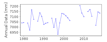
Tide Gauge Data
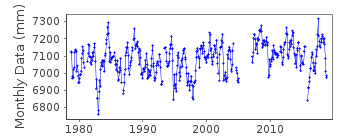
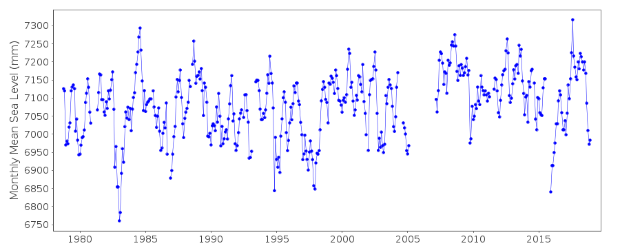
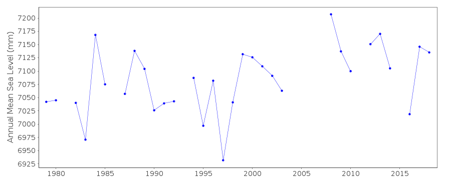
Additional Data Sources (guide to additional data sources)
Nearby GNSS Stations from SONEL: CNMRFast Delivery Data from UHSLC station 28: hourly and daily
Research Quality Data from UHSLC station 28: hourly and daily
Station Documentation
Link to RLR information.Documentation added 1991-06-11
Saipan 700/011 RLR(1983) is 9.2m below BMUH-2Documentation added 1991-10-08
Questionable fluctuations in 1981 and 1986 are due to meteorological events. Typhoon KIM passed near Saipan on 3 December 1986.Documentation added 1996-10-08
Instrument Type: Fischer and Porter Analog-to-Digital RecorderDocumentation added 2010-11-17
The complete dataset 1978-2009 has been supplied by UHSLC. After checking these with existing data values these data have been entered onto the database. RLR remains 5.951m. Areas affected by the Typhoons in 1981 and 1986 were previously flagged. These have now been removed as the data is probably good with meteorological effects. The station remains flagged as obviously the area is prone to earthquake.Documentation added 2013-10-14
Complete dataset Sept. 1978 to April 2012 downloaded onto the database from UHSLCDocumentation added 2015-10-28
The complete dataset from the latest JASL data has been loaded onto the database.Data Authority
University of Hawaii Sea Level CenterDepartment of Oceanography Division of Natural Sciences
1000 Pope Road
Honolulu
Hawaii 96822

![]()
![]()
![]()
