Data
- Obtaining
- Supplying
- High-Frequency
- Bottom Pressure Records
- Other Long Records
- GLOSS/ODINAFRICA Calibration Data
Donate
Donate to PSMSL
Data Notes
- Individual Station Data and Plot Notes
- Referencing the Data Set
- PSMSL Help File
- 2010 Changes to the PSMSL Data Files
Extracted from Database
13 Jul 2026
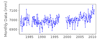
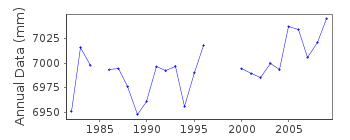
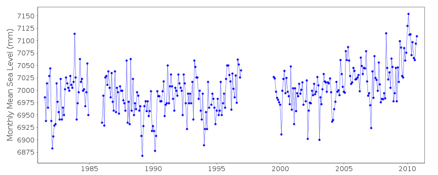
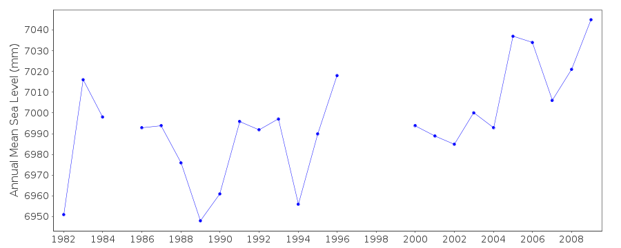
Station Information
| Station ID: | 1524 |
| Latitude: | 44.641667 |
| Longitude: | -67.296667 |
| Coastline code: | 960 |
| Station code: | 196 |
| Country: | UNITED STATES |
| Time span of data: | 1981 – 2010 |
| Completeness (%): | 86 |
| Date of last update: | 23 Jun 2011 |
| Green Arrow: | Current Station |
| Yellow Marker: | Neighbouring RLR Station |
| Red Marker: | Neighbouring Metric Station |
Please note: In many cases, the station position in our database is accurate to only one minute. Thus, the tide gauge may not appear to be on the coast.
Tide Gauge Data
Additional Data Sources (guide to additional data sources)
Nearby GNSS Stations from SONEL: MEMANearby Real Time Stations from VLIZ: cwme, cwme2
Station Documentation
Link to RLR information.Documentation added 1991-06-11
Cutler II 960/196 RLR(1986) is 20.3m below BM 1250 KDocumentation added 1993-07-12
Cutler II 960/196 RLR(1986) is 20.3m below BM 1250 KDocumentation added 2011-12-20
Using NOAA data the RLR diagram has been revised. Previous Primary benchmark1250 K 1978 22.232m relative to gauge datum appears in the NOAA report dated
2010but now with a value of 22.243m. Current Primary benchmark is 1250 M 1991
15.725m relative to TGZ.
Data Authority
N.O.A.A. / N.O.S.N/oes33, Ssmc4, Room 6531
1305 East-West Highway
Silver Spring,
MD 20910

![]()
![]()
![]()
