Data
- Obtaining
- Supplying
- High-Frequency
- Bottom Pressure Records
- Other Long Records
- GLOSS/ODINAFRICA Calibration Data
Donate
Donate to PSMSL
Data Notes
- Individual Station Data and Plot Notes
- Referencing the Data Set
- PSMSL Help File
- 2010 Changes to the PSMSL Data Files
Extracted from Database
13 Jul 2026
Station Information
| Station ID: | 154 |
| Latitude: | 45.647361 |
| Longitude: | 13.758472 |
| GLOSS ID: | 340 |
| Coastline code: | 270 |
| Station code: | 61 |
| Country: | ITALY |
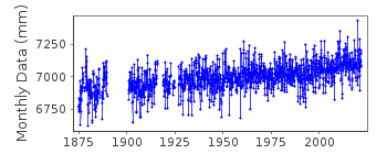
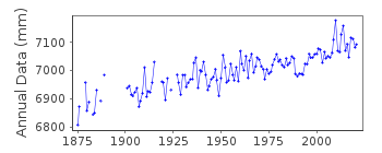
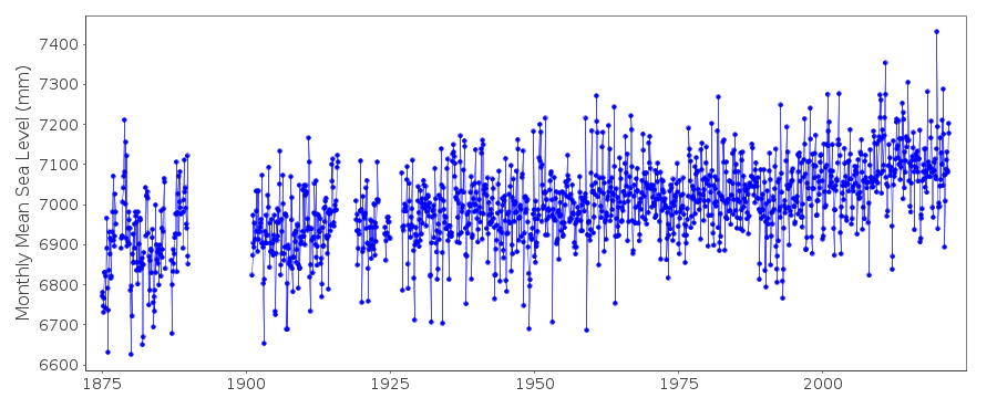
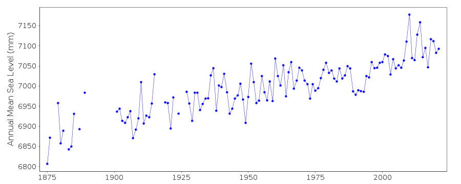
| Time span of data: | 1875 – 2024 |
| Completeness (%): | 90 |
| Date of last update: | 26 Jan 2026 |
| Green Arrow: | Current Station |
| Yellow Marker: | Neighbouring RLR Station |
| Red Marker: | Neighbouring Metric Station |
Please note: In many cases, the station position in our database is accurate to only one minute. Thus, the tide gauge may not appear to be on the coast.
Tide Gauge Data
Additional Data Sources (guide to additional data sources)
Nearby GNSS Stations from SONEL: TRIENearby Real Time Stations from VLIZ: TR22
Fast Delivery Data from UHSLC station 829: hourly and daily
Station Documentation
Link to RLR information.Documentation - date unknown
1875-1889 BASED ON MTLDocumentation added 1994-07-14
Analysis of Trieste data indicates September 1958 larger than expected, compared to neighbouring stations; June-July 1961 smaller; December 1954 to February 1955 smaller; and May-June1955 larger. These values have been checked to be correct as received from authority.
Documentation added 2000-01-25
Trieste 270/061 RLR(1964) is 9.4m below BMDocumentation added 2000-10-03
Some information on Trieste provided by Fabio Raicich (CNR, Trieste) in September 2000:The tide gauge site has always been the same as today, except that before 1926 the station was 10-20 m away from present location, but still on the same pier, namely 'Molo Sartorio'. The present position is 45 deg 38' 50.5" N, 13 deg 45' 30.5" E.
Gauges used have included: 1859-1884: Schaub ; 1884-1911: Strudhoff ; 1911-June 1961 and January 1962-1984: Seibt-Fuess ; June 1961-December 1961: Pagan (a local manufacturer) ; 1966-present: Buesum-Ott ; 1985-present: Pagan ; but only float gauges have been used throughout since the very beginning.
Documentation added 2001-02-13
Trieste data 1905-14 and 1939-99 revised November 2000. The revision has included corrections for the suspect 1958 and 1961 data, but for the 1954 and 1955 queries, no corrections were found (see previous note).Documentation added 2007-10-15
Data from Trieste from 1875-1904 which precede the data in the PSMSL data bank but which are probably of lower accuracy than later data can be found in the paper by Fabio Raicich, Journal of Coastal Research, 23, 1067-1073, 2007.Documentation added 2011-01-13
Comment from data supplier Fabio Raicich:You will notice that the annual mean for 2010 is 6.6cm higher than in 2009, which in turn was the highest ever recorded. I have checked that the data are correct and an explanation is the lowest annual pressure for at least 130 years.
Documentation added 2012-05-10
Historic data for Trieste 1875-1889 and 1901-1904 have been extracted from Fabio Raicichs paper "A Study of Early Trieste Sea Level Data (1875-1914)". The monthly mean sea level data values for the 1800s data were calculated from Mean Tidal Level (MTL) while those for the 1900s were calculated using Mean Sea Level (MSL) from hourly values. As the difference between MSL and MTL is approximately 1mm both sets of monthly means can be combined within the same record. Both sets of monthly means are relative to datum Zero Istituto Talassografico (ZIT).Documentation added 2016-01-22
A value of MTL-MSL=2 mm has been applied to the RLR data for the period 1875-1889. The values were derived using the GESLA2 (high-frequency tide gauge) dataset using harmonic constituents.Documentation added 2016-01-22
We have removed the statement that "DATA 1927-1936, VALUES BASED ON READINGS OF HIGH & LOW WATERS", as it was never correct.Documentation added 2026-01-26
Reuploaded the whole datasetData Authority
CNR - Istituto di Scienze MarineAREA Science Park
Basovizza
I-34149 Trieste
Documentation added 2008-10-31
This authority was formerly called the Istituto Talassograficodi Trieste.

![]()
![]()
![]()
