Data
- Obtaining
- Supplying
- High-Frequency
- Bottom Pressure Records
- Other Long Records
- GLOSS/ODINAFRICA Calibration Data
Donate
Donate to PSMSL
Data Notes
- Individual Station Data and Plot Notes
- Referencing the Data Set
- PSMSL Help File
- 2010 Changes to the PSMSL Data Files
Extracted from Database
13 Jul 2026
Station Information
| Station ID: | 155 |
| Latitude: | 21.306667 |
| Longitude: | -157.866667 |
| GLOSS ID: | 108 |
| Coastline code: | 760 |
| Station code: | 31 |
| Country: | UNITED STATES |
| Time span of data: | 1905 – 2025 |
| Completeness (%): | 100 |
| Date of last update: | 27 Jan 2026 |
| Green Arrow: | Current Station |
| Yellow Marker: | Neighbouring RLR Station |
| Red Marker: | Neighbouring Metric Station |
Please note: In many cases, the station position in our database is accurate to only one minute. Thus, the tide gauge may not appear to be on the coast.
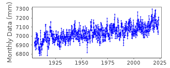
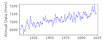
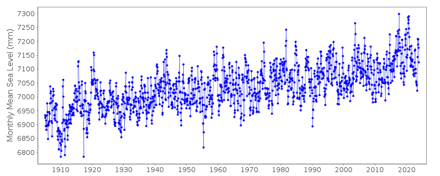
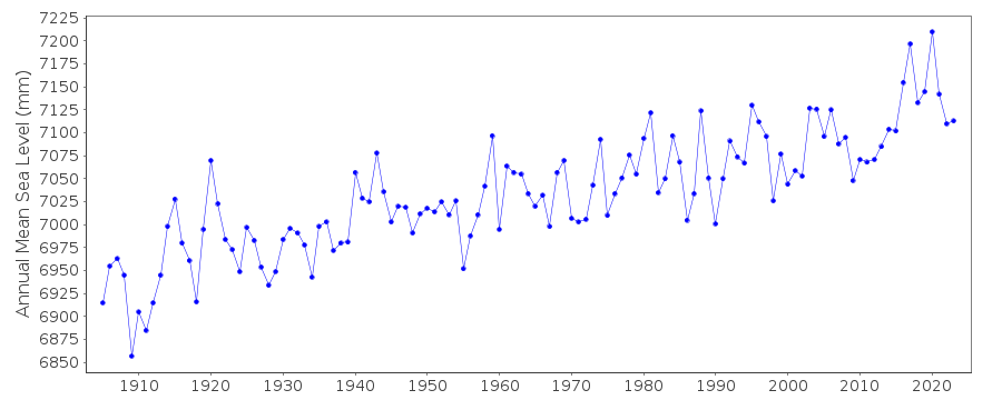
Tide Gauge Data
Additional Data Sources (guide to additional data sources)
Nearby GNSS Stations from SONEL: HNLC, POST, ZHN1Nearby Real Time Stations from VLIZ: hono2, alawa, hono, keehi
Fast Delivery Data from UHSLC station 421: hourly and daily
Fast Delivery Data from UHSLC station 424: hourly and daily
Fast Delivery Data from UHSLC station 57: hourly and daily
Research Quality Data from UHSLC station 57: hourly and daily
Research Quality Data from UHSLC station 26: hourly and daily
Research Quality Data from UHSLC station 27: hourly and daily
Station Documentation
Link to RLR information.Documentation added 1991-06-11
Honolulu 760/031 RLR(1964) is 12.0m below BM2Documentation added 2011-08-24
Using NOAA data the RLR diagram has been re-drawn. Primary benchmark is now B.M. ELV.8.06 FEET 3.734m above gauge datum. The previously used benchmark BM2 still remains but has been given its official title 161 2340 TIDAL 2 as it appears on the NOAA website. Value for 161 2340 TIDAL 2 is 6.347 in the NOAA report of 23.8.2000 and 6.346 in that dated 12.12.2003.Data Authority
N.O.A.A. / N.O.S.N/oes33, Ssmc4, Room 6531
1305 East-West Highway
Silver Spring,
MD 20910

![]()
![]()
![]()
