Data
- Obtaining
- Supplying
- High-Frequency
- Bottom Pressure Records
- Other Long Records
- GLOSS/ODINAFRICA Calibration Data
Donate
Donate to PSMSL
Data Notes
- Individual Station Data and Plot Notes
- Referencing the Data Set
- PSMSL Help File
- 2010 Changes to the PSMSL Data Files
Extracted from Database
13 Jul 2026
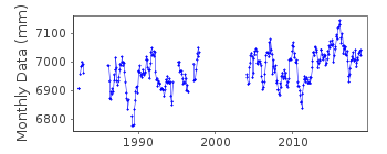
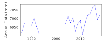
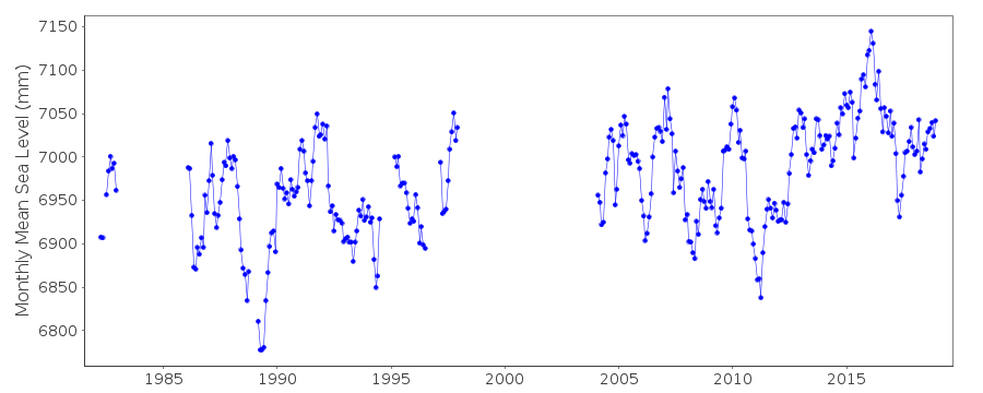
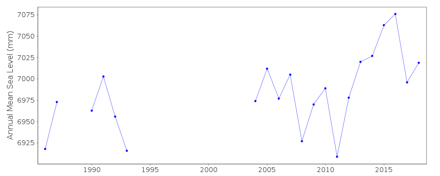
Station Information
| Station ID: | 1555 |
| Latitude: | -8.933333 |
| Longitude: | -140.083333 |
| GLOSS ID: | 142 |
| Coastline code: | 805 |
| Station code: | 11 |
| Country: | FRENCH POLYNESIA |
| Time span of data: | 1982 – 2018 |
| Completeness (%): | 70 |
| Date of last update: | 19 Jun 2025 |
| Green Arrow: | Current Station |
| Yellow Marker: | Neighbouring RLR Station |
| Red Marker: | Neighbouring Metric Station |
Please note: In many cases, the station position in our database is accurate to only one minute. Thus, the tide gauge may not appear to be on the coast.
Tide Gauge Data
Additional Data Sources (guide to additional data sources)
Nearby Real Time Stations from VLIZ: nukuFast Delivery Data from UHSLC station 31: hourly and daily
Research Quality Data from UHSLC station 31: hourly and daily
Station Documentation
Link to RLR information.Documentation - date unknown
GAUGE AT TAIOHAE HARBORDocumentation added 1991-10-16
NO SIMILARITY TO NEIGHBOROURING PAPEETE IN 1982Documentation added 1993-07-12
Nuku Hiva 805/011 RLR(1987) is 8.4m below BM #1Documentation added 1997-11-14
Instrument type: (1982-1983,1986-present) Leupold and Stevens Analog-to-Digital Recorder (ADR); (4/1986-present) Handar Encoder (ENC)Primary gauge: ADR:1982-90, ENC 1991-Documentation added 2013-10-14
Complete dataset April 1982 to Dec. 2012 downloaded onto the database from UHSLCDocumentation added 2014-02-27
Data for Nuku Hiva is available from the SONEL website. Data is supplied to SONEL by SHOM. SHOM has confirmed that the tide gauge at Nuku Hiva belongs to UHSLC. However, SHOM work closely with UHSLC to maintain and control the instrumentation.Documentation added 2025-07-16
Updated the whole dataset to ensure they include all the historical data recovered recently by SHOM and the calculated monthly and annual means match those distributed by SONEL.Data Authority
University of Hawaii Sea Level CenterDepartment of Oceanography Division of Natural Sciences
1000 Pope Road
Honolulu
Hawaii 96822

![]()
![]()
![]()
