Data
- Obtaining
- Supplying
- High-Frequency
- Bottom Pressure Records
- Other Long Records
- GLOSS/ODINAFRICA Calibration Data
Donate
Donate to PSMSL
Data Notes
- Individual Station Data and Plot Notes
- Referencing the Data Set
- PSMSL Help File
- 2010 Changes to the PSMSL Data Files
Extracted from Database
09 Feb 2026
Station Information
| Station ID: | 1571 |
| Latitude: | 8.266667 |
| Longitude: | -82.866667 |
| Coastline code: | 840 |
| Station code: | 2 |
| Country: | PANAMA |
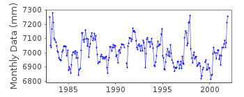
| Time span of data: | 1983 – 2001 |
| Completeness (%): | 99 |
| Date of last update: | 05 Jun 2014 |
| Green Arrow: | Current Station |
| Yellow Marker: | Neighbouring RLR Station |
| Red Marker: | Neighbouring Metric Station |
Please note: In many cases, the station position in our database is accurate to only one minute. Thus, the tide gauge may not appear to be on the coast.
Tide Gauge Data
Additional Data Sources (guide to additional data sources)
Nearby GNSS Stations from SONEL: PUARResearch Quality Data from UHSLC station 304: hourly and daily
Station Documentation
Link to RLR information.Documentation added 1995-09-08
The sea level difference either side of the Panama Canal is approx. 20 cm (higher on the Pacific side) - see for example, Pugh, D.T. 1987, "Tides, surges and mean sea-level", Wiley.RLR 1964 datum at Balboa is 3.112 m below the "Tide Staff Zero" which is itself 12 feet below Panama Canal Precise Level Datum (PLD). On the Atlantic side, at Coco Solo RLR 1993 is 6.288m below the Tide Staff Zero which is itself 2 feet below PLD there. For the older Cristobal data, RLR 1964 is 6.138 m below the Tide Staff Zero which is itself 2 feet below PLD. From inspection of RLR data and from this information, one can indeed verify that sea level is higher on the Pacific side by about 20 cm. However, the accuracy of the PLD national levelling
system is unclear.
Documentation added 2003-02-27
This data series is distiniguished from the original Puerto Armuelles (840/001) data as it has not been possible to link the two series with a common datum.Documentation added 2003-02-27
Puerto Armuelles B 840/002 RLR(1984) is 12.348m below BMA-7-ADocumentation added 2012-01-18
Using data from the latest UHSLC JASL cd additional data for 1999-2001 were added to the 'METRIC' dataset. comparing overlapping data from the cd with previously held data the data values appear to be 8-10mm diferent.Documentation added 2014-06-05
The data values in this time series, up to and including 1991, were supplied directly from the Instituto Geografico Nacional (IGN), Panama. Data values for 1992 onwards were sourced firstly from the TOGA project and later from the UHSLC JASL data holdings. Datum shifts were recorded in the data after 1991. However, because these are accounted for in the JASL metadata the RLR factor for this period remains unchanged. The user should be aware of these shifts if trying to convert the data record to geocentric co-ordinates. The TOGA record itself runs from 1983 and when compared with the IGN data shows sporodic differenes of magnitude 4-16mm.The complete dataset remains RLR.Data Authority
Instituto Geografico NacionalTommy Guardia
Apartado 5267
Panama 5


