Data
- Obtaining
- Supplying
- High-Frequency
- Bottom Pressure Records
- Other Long Records
- GLOSS/ODINAFRICA Calibration Data
Donate
Donate to PSMSL
Data Notes
- Individual Station Data and Plot Notes
- Referencing the Data Set
- PSMSL Help File
- 2010 Changes to the PSMSL Data Files
Extracted from Database
13 Jul 2026
WARNING: QCFLAG EXISTS. PLEASE READ THE DOCUMENTATION.
Station Information
| Station ID: | 162 |
| Latitude: | 37.1 |
| Longitude: | -8.666667 |
| Coastline code: | 210 |
| Station code: | 31 |
| Country: | PORTUGAL |
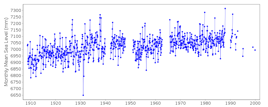
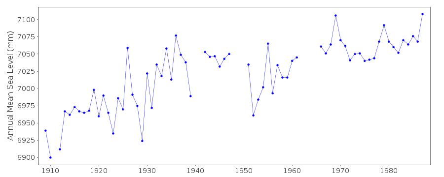
| Time span of data: | 1908 – 1999 |
| Completeness (%): | 78 |
| MTL Data: | 1908-1958 |
| MTL-MSL (mm): | 7 |
| Date of last update: | 27 Jan 2016 |
| Green Arrow: | Current Station |
| Yellow Marker: | Neighbouring RLR Station |
| Red Marker: | Neighbouring Metric Station |
Please note: In many cases, the station position in our database is accurate to only one minute. Thus, the tide gauge may not appear to be on the coast.
Tide Gauge Data
Additional Data Sources (guide to additional data sources)
Nearby GNSS Stations from SONEL: LAGONearby Real Time Stations from VLIZ: lgos
Research Quality Data from UHSLC station 723: hourly and daily
Station Documentation
Link to RLR information.Documentation - date unknown
Data from 2 sites prior to 1959 MSL values based on readings of high and low waters.Data prior to 1962 referred to BM which has proved unstable irregularities in records for 1940 & 1941. 1940-41. Data therefore ommitted gauge at new site in September 1965.Documentation added 1991-06-11
Lagos 210/031 RLR(1974) is 10.0m below BMOPDocumentation added 1992-08-06
The 1941 irreularities may be connected with the 1941 earthquake - See Bottari et al. , tecttonophysics 202, 269-275, 1992 and Yamguti, R.Soc.New Zealand bulletin , 9, 127-128, 1971.Documentation added 1997-01-14
Data for 1985-88 revised, January 1997Documentation added 2001-03-28
Data for 1986-87,90-92,95,99 updated March 2001 Lagos is an historic station last data 1999Documentation added 2016-01-22
A value of MTL-MSL=7 mm has been applied to the RLR data for the period 1908-1958. The values were derived using the GESLA2 (high-frequency tide gauge) dataset using harmonic constituents.Data Authority
Instituto Port. de Cartografia e CadastroRua de Artilharia Um, No. 107
P - 1070 Lisboa

![]()
![]()
![]()
