Data
- Obtaining
- Supplying
- High-Frequency
- Bottom Pressure Records
- Other Long Records
- GLOSS/ODINAFRICA Calibration Data
Donate
Donate to PSMSL
Data Notes
- Individual Station Data and Plot Notes
- Referencing the Data Set
- PSMSL Help File
- 2010 Changes to the PSMSL Data Files
Extracted from Database
20 Jul 2026
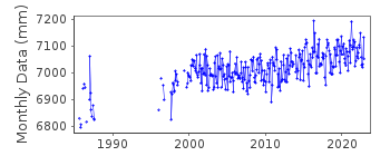
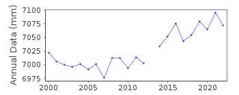
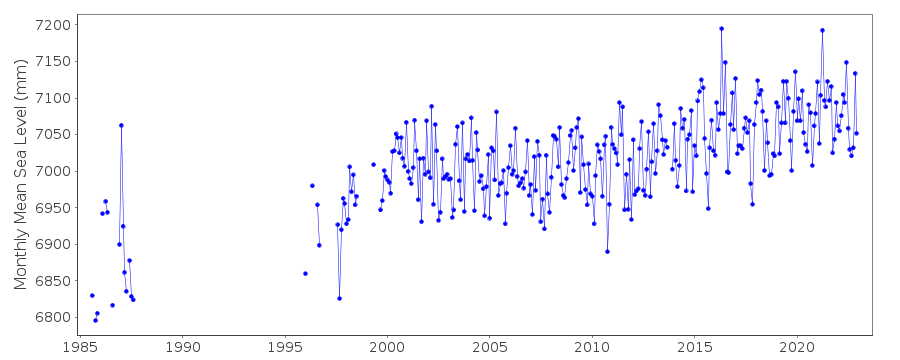
Station Information
| Station ID: | 1643 |
| Latitude: | -45.8147 |
| Longitude: | 170.62414 |
| Coastline code: | 690 |
| Station code: | 28 |
| Country: | NEW ZEALAND |
| Time span of data: | 1985 – 2025 |
| Completeness (%): | 70 |
| Date of last update: | 17 Feb 2026 |
| Green Arrow: | Current Station |
| Yellow Marker: | Neighbouring RLR Station |
| Red Marker: | Neighbouring Metric Station |
Please note: In many cases, the station position in our database is accurate to only one minute. Thus, the tide gauge may not appear to be on the coast.
Tide Gauge Data
Additional Data Sources (guide to additional data sources)
Nearby GNSS Stations from SONEL: DUNT, DUND, OUS2Nearby Real Time Stations from VLIZ: otat
Research Quality Data from UHSLC station 669: hourly and daily
Station Documentation
Link to RLR information.Documentation added 2003-01-17
New data from John Hannah added 17/01/03 which supercedes old data.New data does not have any missing days information.
Old data has been backed up.
Documentation added 2003-01-17
New data from John Hannah was for Auckland II, Dunedin II,Lyttelton II and Wellington II.
Documentation added 2005-10-17
There is a new John Hannah paper referring to New Zealand data forWellington, Dunedin, Lyttelton and Auckland. The reference is:
"An updated analysis of long-term sea level change in New Zealand."
Geophysical Research Letters, V31, L03307, doi:10.1029/2003GL019166
(2004).
Documentation added 2008-10-01
Dataset for Port Chalmers 1985-2007received from Glen Rowe at LINZ.
This is a new station to PSMSL.
Documentation added 2009-10-07
New Zealand station Port Chalmers is now an RLRstation. RLR value=5.885
Documentation added 2021-08-23
A revised copy of the New Zealand data values for station Port Chalmers has been received from the data supplier the Land Information New Zealand (LINZ). The revised dataset begins in 2014. This exercise has been carried out to correct some anomalies with the high frequency data.Data Authority
Land Information New Zealand155 The Terrace
PO 5501
Wellington 6145

![]()
![]()
![]()
