Data
- Obtaining
- Supplying
- High-Frequency
- Bottom Pressure Records
- Other Long Records
- GLOSS/ODINAFRICA Calibration Data
Donate
Donate to PSMSL
Data Notes
- Individual Station Data and Plot Notes
- Referencing the Data Set
- PSMSL Help File
- 2010 Changes to the PSMSL Data Files
Extracted from Database
20 Jul 2026
Station Information
| Station ID: | 1645 |
| Latitude: | -0.433333 |
| Longitude: | -90.283333 |
| GLOSS ID: | 169 |
| Coastline code: | 845 |
| Station code: | 34 |
| Country: | ECUADOR |
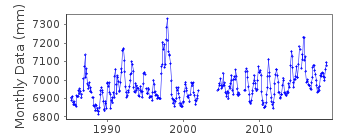
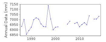
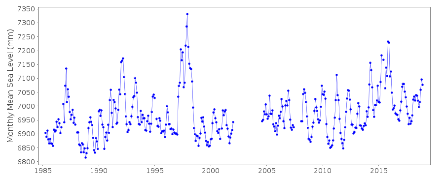
| Time span of data: | 1985 – 2018 |
| Completeness (%): | 89 |
| Link to ellipsoid: | Available |
| Date of last update: | 29 Jan 2020 |
| Green Arrow: | Current Station |
| Yellow Marker: | Neighbouring RLR Station |
| Red Marker: | Neighbouring Metric Station |
Please note: In many cases, the station position in our database is accurate to only one minute. Thus, the tide gauge may not appear to be on the coast.
Tide Gauge Data
Additional Data Sources (guide to additional data sources)
Nearby Real Time Stations from VLIZ: baltFast Delivery Data from UHSLC station 3: hourly and daily
Research Quality Data from UHSLC station 3: hourly and daily
Station Documentation
Link to RLR information.Documentation added 1993-07-12
Baltra-B 845/034 RLR(1987) is 9.3m below BM UH-2Documentation added 1997-11-12
1985-90 primary gauge = Leupold and Stevens Analog-to-Digital Recorder (ADR)1991- primary gauge = Handar Encoder (ENC)Documentation added 2010-11-17
Complete dataset April 1985 - June 2010 received from UHSLC. After checking these with existing data values these has been loaded onto the database. RLR remains 5.111mDocumentation added 2013-10-14
Full dataset March 1985-April 2012 downloaded from Hawaii. Dataset replaced.Documentation added 2015-09-22
The information for the RLR diagram was drawn with information from the first levelling exercise in 1985. Since then benchmark UH2 has moved slightly in subsequent levelling exercises. The last levelling was carried out in 2014 since 2004 the stable benchmark is benchmark 1 4.1686m relative to the datum.Documentation added 2015-10-21
Using the latest JASL data the complete dataset 1985-2014 has been loaded.Data Authority
University of Hawaii Sea Level CenterDepartment of Oceanography Division of Natural Sciences
1000 Pope Road
Honolulu
Hawaii 96822

![]()
![]()
![]()
