Data
- Obtaining
- Supplying
- High-Frequency
- Bottom Pressure Records
- Other Long Records
- GLOSS/ODINAFRICA Calibration Data
Donate
Donate to PSMSL
Data Notes
- Individual Station Data and Plot Notes
- Referencing the Data Set
- PSMSL Help File
- 2010 Changes to the PSMSL Data Files
Extracted from Database
13 Jul 2026
Station Information
| Station ID: | 1674 |
| Latitude: | 22.291111 |
| Longitude: | 114.213333 |
| GLOSS ID: | 77 |
| Coastline code: | 611 |
| Station code: | 10 |
| Country: | HONG KONG |
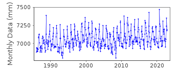
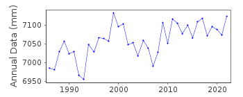
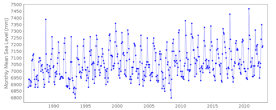
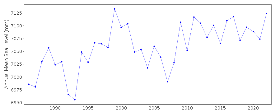
| Time span of data: | 1986 – 2025 |
| Completeness (%): | 100 |
| Link to ellipsoid: | Available |
| Date of last update: | 20 May 2026 |
| Green Arrow: | Current Station |
| Yellow Marker: | Neighbouring RLR Station |
| Red Marker: | Neighbouring Metric Station |
Please note: In many cases, the station position in our database is accurate to only one minute. Thus, the tide gauge may not appear to be on the coast.
Tide Gauge Data
Additional Data Sources (guide to additional data sources)
Nearby GNSS Stations from SONEL: HKQT, HKSC, HKOHNearby Real Time Stations from VLIZ: quar
Fast Delivery Data from UHSLC station 329: hourly and daily
Research Quality Data from UHSLC station 329: hourly and daily
Station Documentation
Link to RLR information.Documentation added 1998-10-07
This station Quarry Bay replaced station North Point (611/011) from 1986.Documentation added 1999-12-03
According to Dr.Baki Iz (Hong Kong Polytechnic University) reference benchmarks at the North Point and Quarry Bay gauges show from episodic levelling significant settlement with respectto neighbouring marks (October 1998). However, data provided for these sites are conventionally referred to the more stable Principal Datum and Rifleman's Bolt benchmark by means of frequent levelling. Note that the North Point and Quarry Bay datums are the same and their RLR time series may be combined to make one continuous record if wished with reasonable confidence.
Documentation added 1999-12-03
Quarry Bay, HK 611/010 RLR(1975, NP) is 11.2m below Rifleman's BoltDocumentation added 2002-01-09
For an analysis of sea level changes in Hong Kong, see "Sea level changes in Hong Kong from tide gauge measurements" by X.Ding et al., Journal of Geodesy, 74, 683-689, 2001 and "Long-term sea-level changes in Hong Kong from tide-gauge records" by X.Ding et al., Journal of Coastal Research,17, 749-754, 2001.Documentation added 2010-07-12
As no data exists for 1975 from Quarry Bay (see comments above) to produce an updated RLR diagram from the database an alternative year was selected. The RLR was generated using 1986 as the RLR year. This does not alter any of the relevant numbers and the RLR factor remains 5.619. RLR (1986) also remains 11.2m below the Fundamental Bench Mark (Rifleman's Bolt).Documentation added 2016-08-03
Using information from the datasheet the height for the Primary benchmark to the TGZ has been revised from 5.581m to 5.580m. As a result the RLR factor has changed from 5.619m to 5.62mData Authority
Hong Kong Observatory134A Nathan Road
Kowloon
Documentation added 2000-06-08
The Hong Kong Observatory was formerly known as the Royal Observatory.

![]()
![]()
![]()
