Data
- Obtaining
- Supplying
- High-Frequency
- Bottom Pressure Records
- Other Long Records
- GLOSS/ODINAFRICA Calibration Data
Donate
Donate to PSMSL
Data Notes
- Individual Station Data and Plot Notes
- Referencing the Data Set
- PSMSL Help File
- 2010 Changes to the PSMSL Data Files
Extracted from Database
20 Jul 2026
Station Information
| Station ID: | 1695 |
| Latitude: | 38.033333 |
| Longitude: | 24 |
| Coastline code: | 290 |
| Station code: | 32 |
| Country: | GREECE |
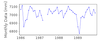
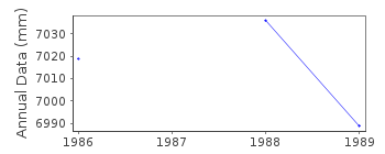
| Time span of data: | 1986 – 1989 |
| Completeness (%): | 96 |
| Date of last update: | 28 Nov 1994 |
| Green Arrow: | Current Station |
| Yellow Marker: | Neighbouring RLR Station |
| Red Marker: | Neighbouring Metric Station |
Please note: In many cases, the station position in our database is accurate to only one minute. Thus, the tide gauge may not appear to be on the coast.
Tide Gauge Data
Additional Data Sources (guide to additional data sources)
Nearby GNSS Stations from SONEL: NOA1, DYNGStation Documentation
Link to RLR information.Documentation added 2000-04-25
Rafina 290/032 RLR(1988) is 10.5m below BM R1Rafina is now an historic station last data 1989
Data Authority
Hellenic Navy Hydrographic ServiceGeographic Policy and International Relations Office
TGN 1040
Athens

![]()
![]()
![]()
