Data
- Obtaining
- Supplying
- High-Frequency
- Bottom Pressure Records
- Other Long Records
- GLOSS/ODINAFRICA Calibration Data
Donate
Donate to PSMSL
Data Notes
- Individual Station Data and Plot Notes
- Referencing the Data Set
- PSMSL Help File
- 2010 Changes to the PSMSL Data Files
Extracted from Database
13 Jul 2026
Station Information
| Station ID: | 174 |
| Latitude: | 11.8 |
| Longitude: | 99.816667 |
| GLOSS ID: | 39 |
| Coastline code: | 600 |
| Station code: | 21 |
| Country: | THAILAND |
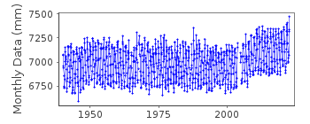
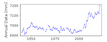
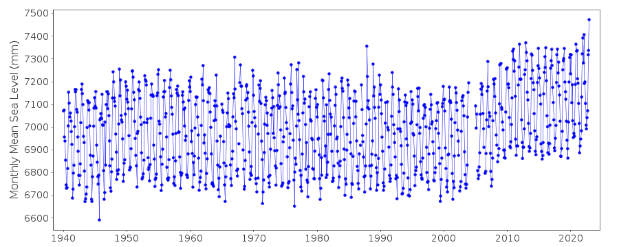
| Time span of RLR data: | 1940 – 2024 |
| RLR completeness (%): | 97 |
| Time span of metric data: | 1910 – 2024 |
| Metric completeness (%): | 76 |
| Date of last update: | 04 Aug 2025 |
| Green Arrow: | Current Station |
| Yellow Marker: | Neighbouring RLR Station |
| Red Marker: | Neighbouring Metric Station |
Please note: In many cases, the station position in our database is accurate to only one minute. Thus, the tide gauge may not appear to be on the coast.
Tide Gauge Data
Additional Data Sources (guide to additional data sources)
Fast Delivery Data from UHSLC station 328: hourly and dailyResearch Quality Data from UHSLC station 328: hourly and daily
Station Documentation
Link to RLR information.Documentation - date unknown
Data for 1910-1915 supplied by the Royal Thai Navy BangkokDocumentation added 1991-06-11
Ko Lak 600/021 RLR(1981) is 8.4m below BM ADocumentation added 2009-07-01
Although the data for Ko Lak 2008 was supplied directly from The Hydrographic Dept. of the Royal Thai Navy the missing days information was erroneous. When queried with them they insistedthat the figures were correct (missing days included 720,95 days) so figures were obviously wrong. Decision was taken to use the missing day information for 2008 from the JASL CD.
Data Authority
Oceanographic DivisionHydrographic Department
Royal Thai Navy
222 Rimtang-Rodfai-kao Road
Bangna, Bangkok 10260

![]()
![]()
![]()
