Data
- Obtaining
- Supplying
- High-Frequency
- Bottom Pressure Records
- Other Long Records
- GLOSS/ODINAFRICA Calibration Data
Donate
Donate to PSMSL
Data Notes
- Individual Station Data and Plot Notes
- Referencing the Data Set
- PSMSL Help File
- 2010 Changes to the PSMSL Data Files
Extracted from Database
13 Jul 2026
Station Information
| Station ID: | 1740 |
| Latitude: | -7.283333 |
| Longitude: | 72.4 |
| GLOSS ID: | 26 |
| Coastline code: | 453 |
| Station code: | 3 |
| Country: | BRITISH INDIAN OCEAN TERRITORY |
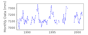
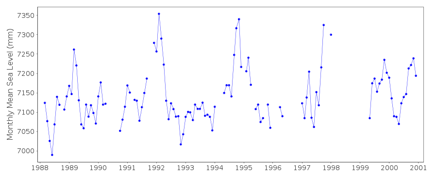
| Time span of data: | 1988 – 2000 |
| Completeness (%): | 72 |
| Date of last update: | 17 Oct 2002 |
| Green Arrow: | Current Station |
| Yellow Marker: | Neighbouring RLR Station |
| Red Marker: | Neighbouring Metric Station |
Please note: In many cases, the station position in our database is accurate to only one minute. Thus, the tide gauge may not appear to be on the coast.
Tide Gauge Data
Additional Data Sources (guide to additional data sources)
Nearby GNSS Stations from SONEL: DGAR, DGAVNearby Real Time Stations from VLIZ: garc
Fast Delivery Data from UHSLC station 104: hourly and daily
Research Quality Data from UHSLC station 104: hourly and daily
Station Documentation
Link to RLR information.Documentation added 2000-03-28
DATA FROM US NAVAL OCEANOGRAPHIC COMMAND DETACHMENT VIA HAWAIISEA LEVEL CENTER.
Documentation added 2000-03-28
Diego Garcia-C 453/003 RLR(1993) is 10.7m below BM 1000 D 1990Documentation added 2000-03-28
Data from before 1992 (i.e. from before the establishment of NGWLMS gaugeby NOS) were from a UH gauge about 10 metres away
This is now an historic station last data is 2000
Data Authority
Naval Oceanographic Command DetachmentF.P.O.
San Francisco
CA 96885-2905

![]()
![]()
![]()
