Data
- Obtaining
- Supplying
- High-Frequency
- Bottom Pressure Records
- Other Long Records
- GLOSS/ODINAFRICA Calibration Data
Donate
Donate to PSMSL
Data Notes
- Individual Station Data and Plot Notes
- Referencing the Data Set
- PSMSL Help File
- 2010 Changes to the PSMSL Data Files
Extracted from Database
20 Jul 2026
Station Information
| Station ID: | 1774 |
| Latitude: | 53.449694 |
| Longitude: | -3.018 |
| Coastline code: | 170 |
| Station code: | 214 |
| Country: | UNITED KINGDOM |
| Time span of data: | 1991 – 2025 |
| Completeness (%): | 71 |
| Date of last update: | 19 Feb 2026 |
| Green Arrow: | Current Station |
| Yellow Marker: | Neighbouring RLR Station |
| Red Marker: | Neighbouring Metric Station |
Please note: In many cases, the station position in our database is accurate to only one minute. Thus, the tide gauge may not appear to be on the coast.
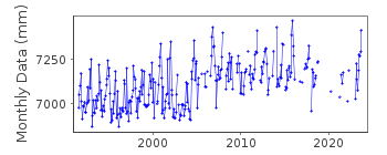
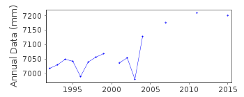
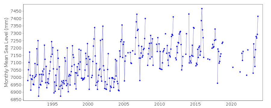
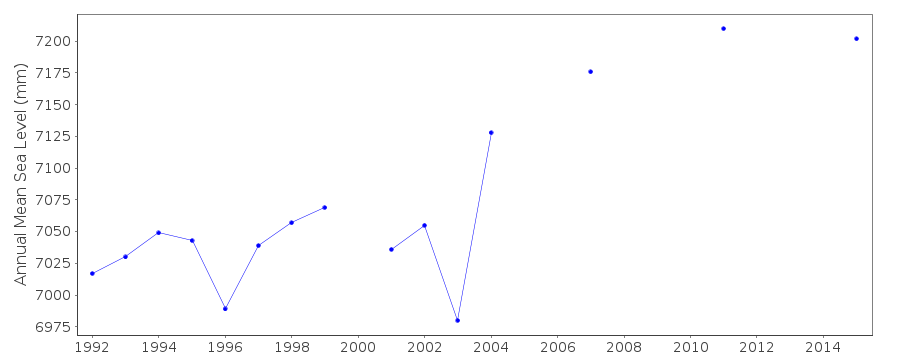
Tide Gauge Data
Additional Data Sources (guide to additional data sources)
Nearby GNSS Stations from SONEL: LIVENearby Real Time Stations from VLIZ: live2, live
Station Documentation
Link to RLR information.Documentation added 1994-07-20
Gauge is an "A Class" bubbler maintained by POL.Documentation added 2000-04-25
L'pool Gladstone 170/214 RLR(1994) is 16.3m below BM SJ 3249 9525Documentation added 2001-01-02
Recent work on vertical land movements in the UK can be found from the University of Nottingham web site: http://ukcogr.iessg.nottingham.ac.uk/~eosi/Documentation added 2006-11-15
Historic tide gauge information: Dataring installed in May 1991. Around building shows signs of subsidence. Pressure points re-levelled December 2001. January 2002 mid-tide connected. 2 O.S. benchmarks demolished while the remaining 2 were unstable. April 2002 site re-levelled using new benchmark on the other side of the dock. TGBM had dropped 148mm. Datum of gauge re-set.Documentation added 2009-01-28
Treat data 2006 onwards as suspect. Data for Liverpool (Gladstone Dock) looks high from 2004 onwards particularly when viewed as annual rather than monthly means.Documentation added 2012-05-17
Data looks 'high' 2004 onwards especially when viewed as annual means.Documentation added 2012-07-26
It has now been realised that some areas surrounding Gladstone Dock are subsiding. Levelling investigation is to be carried out around the TGBM to try to accertain which areas are effected. There will be ongoing monitoring at site.Documentation added 2014-07-03
There were several visits to site during 2013. 16.01.2013 TGi carried out installation in the refurbished building. 06.03.2013 two new benchmarks were established at either end of Gladstone Dock. 12.11.2013 site survey was carried out and a meeting held with the surveyors. It is known that the pier is subsiding.During April and May 2013 both full tide channels were recording ~40mm high. The two new benchmarks should monitor any movement.By the end of July channel 2 was fluctuating between 20mm low and 30mm high. From September channel 2 was showing ~60mm low on several falling tides.Documentation added 2015-06-02
The pier at Liverpool is subsiding Channel2 was ~60mm low on falling tides. TGI visited the site on a number of occasions sometimes to liase with Environment Agency personnel.Data Authority
Environment AgencyHorizon House
Deanery Road
BS1 5AH
Bristol

![]()
![]()
![]()
