Data
- Obtaining
- Supplying
- High-Frequency
- Bottom Pressure Records
- Other Long Records
- GLOSS/ODINAFRICA Calibration Data
Donate
Donate to PSMSL
Data Notes
- Individual Station Data and Plot Notes
- Referencing the Data Set
- PSMSL Help File
- 2010 Changes to the PSMSL Data Files
Extracted from Database
13 Jul 2026
Station Information
| Station ID: | 1784 |
| Latitude: | 16.2244 |
| Longitude: | -61.531399 |
| Coastline code: | 914 |
| Station code: | 1 |
| Country: | GUADELOUPE |
| Time span of data: | 1983 – 2025 |
| Completeness (%): | 61 |
| Link to ellipsoid: | Available |
| Date of last update: | 20 Feb 2026 |
| Green Arrow: | Current Station |
| Yellow Marker: | Neighbouring RLR Station |
| Red Marker: | Neighbouring Metric Station |
Please note: In many cases, the station position in our database is accurate to only one minute. Thus, the tide gauge may not appear to be on the coast.
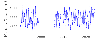
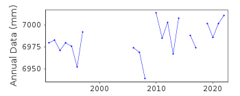
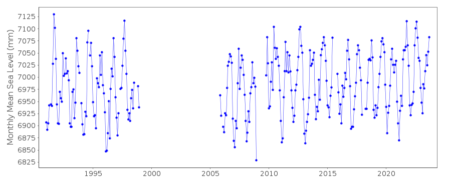
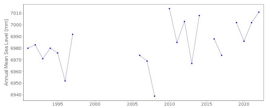
Tide Gauge Data
Additional Data Sources (guide to additional data sources)
Nearby GNSS Stations from SONEL: ABMF, PPTG, FFE0Nearby Real Time Stations from VLIZ: ptpt2, ptpt
Research Quality Data from UHSLC station 272: hourly and daily
Station Documentation
Link to RLR information.Documentation added 1996-02-07
data received from TOGA centreDocumentation added 1998-12-10
data for 1994-95 revised, December 1998Documentation added 2010-05-19
This is a 'Metric' station benchmark information for the early data could not be found. From the report in new_data/SHOM_port_info_reports primary benchmark is given as IGN no.12-GO 2.883m above TGZ.Documentation added 2011-02-01
From data found on the SHOM website. Documentation confirms the Primary benchmark to be IGN no 12 - GO 2.883m above ZH - Zero Hydrographic.It also confirmed that the benchmark dates from 1988.Documentation added 2014-02-18
To agree with the leveling sheet on SONEL website the benchmark name has been changed to C.Documentation added 2014-10-01
Using data from the SONEL website the latitude and longitude for Pointe a Pitre have been revised.Documentation added 2016-06-21
When adding the 2015 data to the dataset it was noted that the datapoints for January-March 2011 had been revised.Documentation added 2025-07-15
Updated the whole dataset to ensure they include all the historical data recovered recently by SHOM and the calculated monthly and annual means match those distributed by SONEL.Data Authority
Meteo-FranceDirection Interregionale Antilles-Guyane
B.P. 645
97262 Fort-de-France CEDEX

![]()
![]()
![]()
