Data
- Obtaining
- Supplying
- High-Frequency
- Bottom Pressure Records
- Other Long Records
- GLOSS/ODINAFRICA Calibration Data
Donate
Donate to PSMSL
Data Notes
- Individual Station Data and Plot Notes
- Referencing the Data Set
- PSMSL Help File
- 2010 Changes to the PSMSL Data Files
Extracted from Database
13 Jul 2026
WARNING: QCFLAG EXISTS. PLEASE READ THE DOCUMENTATION.
Station Information
| Station ID: | 1840 |
| Latitude: | -13.826778 |
| Longitude: | -171.761306 |
| Coastline code: | 746 |
| Station code: | 2 |
| Country: | SAMOA |
| Time span of data: | 1993 – 2026 |
| Completeness (%): | 95 |
| Link to ellipsoid: | Available |
| Date of last update: | 01 Jun 2026 |
| Green Arrow: | Current Station |
| Yellow Marker: | Neighbouring RLR Station |
| Red Marker: | Neighbouring Metric Station |
Please note: In many cases, the station position in our database is accurate to only one minute. Thus, the tide gauge may not appear to be on the coast.
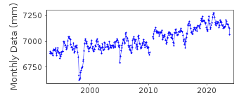
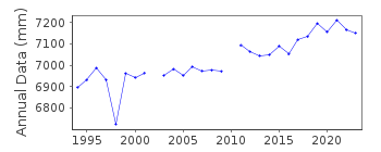
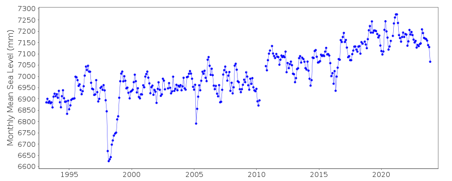
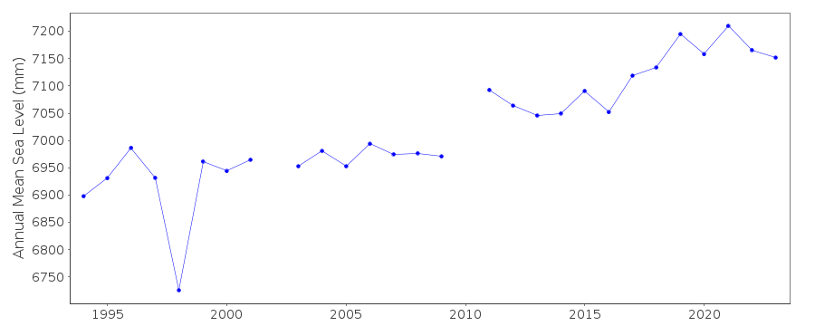
Tide Gauge Data
Additional Data Sources (guide to additional data sources)
Nearby GNSS Stations from SONEL: SAMONearby Real Time Stations from VLIZ: upol
Fast Delivery Data from UHSLC station 401: hourly and daily
Research Quality Data from UHSLC station 401: hourly and daily
Station Documentation
Link to RLR information.Documentation added 1998-01-13
National Tidal Facility SEAFRAME stationDocumentation added 2010-08-25
Supplying authority (NTC) have confirmed that all data refers to LAT (93-94). Tide gauge benchmark BM 201 is 2.0229 m above LAT. RLR (2009) is defined as 8.2 m below BM 201Documentation added 2010-08-25
Sensor appears to be subsiding NTC's Pacific country report for Samoa (December 2009) states that over the period 1992-2009, the sensor has fallen relative to the TGBM by 0.9 mm per yearDocumentation added 2021-02-03
As well as adding 2020 data the value for March 2019 has been revised.Data Authority
National Tidal CentreBureau of Meteorology
PO Box 421
Kent Town 5071
South Australia
Documentation added 2010-08-12
Formerly known as the National Tidal Facility

![]()
![]()
![]()
