Data
- Obtaining
- Supplying
- High-Frequency
- Bottom Pressure Records
- Other Long Records
- GLOSS/ODINAFRICA Calibration Data
Donate
Donate to PSMSL
Data Notes
- Individual Station Data and Plot Notes
- Referencing the Data Set
- PSMSL Help File
- 2010 Changes to the PSMSL Data Files
Extracted from Database
13 Jul 2026
Station Information
| Station ID: | 189 |
| Latitude: | -20.317583 |
| Longitude: | 118.574417 |
| GLOSS ID: | 51 |
| Coastline code: | 680 |
| Station code: | 494 |
| Country: | AUSTRALIA |
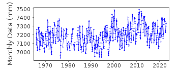
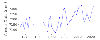
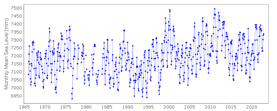
| Time span of RLR data: | 1966 – 2024 |
| RLR completeness (%): | 93 |
| Time span of metric data: | 1913 – 2024 |
| Metric completeness (%): | 56 |
| Date of last update: | 01 Jun 2026 |
| Green Arrow: | Current Station |
| Yellow Marker: | Neighbouring RLR Station |
| Red Marker: | Neighbouring Metric Station |
Please note: In many cases, the station position in our database is accurate to only one minute. Thus, the tide gauge may not appear to be on the coast.
Tide Gauge Data
Additional Data Sources (guide to additional data sources)
Nearby GNSS Stations from SONEL: PTHLFast Delivery Data from UHSLC station 169: hourly and daily
Research Quality Data from UHSLC station 169: hourly and daily
Station Documentation
Link to RLR information.Documentation added 1995-05-02
Station density along some sections of the Australian coast has meant that station codes 601 onwards have been re-ordered compared to those in earlier versions of the PSMSL data set. Data up to 1960 was supplied by C.S.I.R.O, Tasmania.Documentation added 1996-05-20
Revised data 1960-1985 supplied by the National Tidal Centre, Bureau of Meteorolgy, South Australia.Documentation added 2002-05-27
Port Hedland 680/494 RLR(2000) is 12.761m below BM DMH 101Documentation added 2008-02-25
Port Hedland 680/494 RLR(2000) is 12.762m below BM PA26Data Authority
National Tidal CentreBureau of Meteorology
PO Box 421
Kent Town 5071
South Australia
Documentation added 2010-08-12
Formerly known as the National Tidal Facility

![]()
![]()
![]()
