Data
- Obtaining
- Supplying
- High-Frequency
- Bottom Pressure Records
- Other Long Records
- GLOSS/ODINAFRICA Calibration Data
Donate
Donate to PSMSL
Data Notes
- Individual Station Data and Plot Notes
- Referencing the Data Set
- PSMSL Help File
- 2010 Changes to the PSMSL Data Files
Extracted from Database
13 Jul 2026
Station Information
| Station ID: | 1925 |
| Latitude: | 6.980528 |
| Longitude: | 158.200222 |
| GLOSS ID: | 115 |
| Coastline code: | 710 |
| Station code: | 32 |
| Country: | MICRONESIA, FEDERATED STATES OF |
| Time span of data: | 2002 – 2026 |
| Completeness (%): | 87 |
| Link to ellipsoid: | Available |
| Date of last update: | 01 Jun 2026 |
| Green Arrow: | Current Station |
| Yellow Marker: | Neighbouring RLR Station |
| Red Marker: | Neighbouring Metric Station |
Please note: In many cases, the station position in our database is accurate to only one minute. Thus, the tide gauge may not appear to be on the coast.
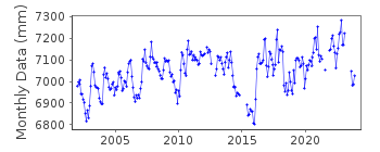
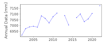
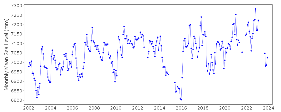
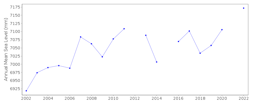
Tide Gauge Data
Additional Data Sources (guide to additional data sources)
Nearby GNSS Stations from SONEL: POHNNearby Real Time Stations from VLIZ: deke
Fast Delivery Data from UHSLC station 1: hourly and daily
Research Quality Data from UHSLC station 1: hourly and daily
Station Documentation
Link to RLR information.Documentation added 2010-08-26
Supplying authority has confirmed that tide gauge benchmark FSM1 is 2.438 m above TGZ RLR (2009) has been defined as 8.7 m below FSM1Documentation added 2016-03-16
Pohnpei C has been buddy checked with the UH gauge Pohnpei B id.1370 although the data for 2015 is not yet available the profiles compare well.Documentation added 2019-01-23
Many data values prior to 2010 have been revised. Because of this the complete data series has been re-loaded.Data Authority
National Tidal CentreBureau of Meteorology
PO Box 421
Kent Town 5071
South Australia
Documentation added 2010-08-12
Formerly known as the National Tidal Facility

![]()
![]()
![]()
