Data
- Obtaining
- Supplying
- High-Frequency
- Bottom Pressure Records
- Other Long Records
- GLOSS/ODINAFRICA Calibration Data
Donate
Donate to PSMSL
Data Notes
- Individual Station Data and Plot Notes
- Referencing the Data Set
- PSMSL Help File
- 2010 Changes to the PSMSL Data Files
Extracted from Database
13 Jul 2026
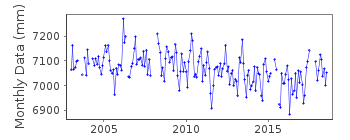
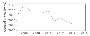
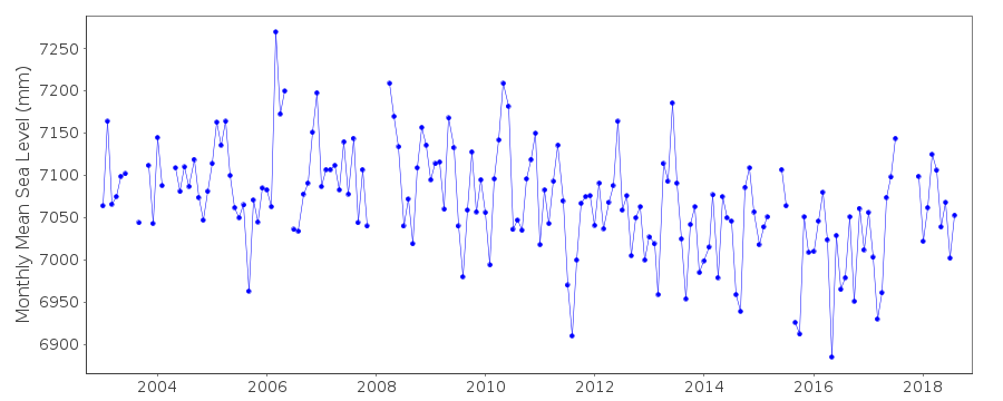
Station Information
| Station ID: | 1931 |
| Latitude: | -67.571256 |
| Longitude: | -68.129797 |
| GLOSS ID: | 342 |
| Coastline code: | 999 |
| Station code: | 103 |
| Country: | ANTARCTICA |
| Time span of data: | 2003 – 2018 |
| Completeness (%): | 89 |
| Link to ellipsoid: | Available |
| Date of last update: | 11 Jun 2019 |
| Green Arrow: | Current Station |
| Yellow Marker: | Neighbouring RLR Station |
| Red Marker: | Neighbouring Metric Station |
Please note: In many cases, the station position in our database is accurate to only one minute. Thus, the tide gauge may not appear to be on the coast.
Tide Gauge Data
Additional Data Sources (guide to additional data sources)
Nearby GNSS Stations from SONEL: ROTHNearby Real Time Stations from VLIZ: rothe
Research Quality Data from UHSLC station 832: hourly and daily
Station Documentation
Link to RLR information.Documentation added 2005-08-08
Rothera A /103 RLR(2002) is 10.923m below Well Head BMThe Well Head BM is deemed to be the primary benchmark as it is more stable
than the Jetty BM
Data Authority
British Oceanographic Data CentreNational Oceanography Centre
Joseph Proudman Building, 6 Brownlow Street
Liverpool
L3 5DA

![]()
![]()
![]()
