Data
- Obtaining
- Supplying
- High-Frequency
- Bottom Pressure Records
- Other Long Records
- GLOSS/ODINAFRICA Calibration Data
Donate
Donate to PSMSL
Data Notes
- Individual Station Data and Plot Notes
- Referencing the Data Set
- PSMSL Help File
- 2010 Changes to the PSMSL Data Files
Extracted from Database
13 Jul 2026
Station Information
| Station ID: | 1933 |
| Latitude: | 39.6282 |
| Longitude: | 19.905317 |
| Coastline code: | 290 |
| Station code: | 103 |
| Country: | GREECE |
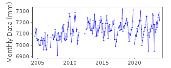
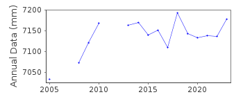
| Time span of data: | 2004 – 2025 |
| Completeness (%): | 87 |
| Date of last update: | 13 Mar 2026 |
| Green Arrow: | Current Station |
| Yellow Marker: | Neighbouring RLR Station |
| Red Marker: | Neighbouring Metric Station |
Please note: In many cases, the station position in our database is accurate to only one minute. Thus, the tide gauge may not appear to be on the coast.
Tide Gauge Data
Station Documentation
Link to RLR information.Documentation added 2008-04-02
CORFU CITY began operating in August 2004.Documentation added 2011-02-15
From information supplied Primary benchmark was taken as R 31 1.660m relativeto TGZ. Giving a RLR factor of 8.040m. Currently sea level is recorded
downwards.
Other benchmarks are:
R 20 YY 1.082m relative to TGZ
R 10 YY 0.485m relative to TGZ
RGYS 0.285m relative to TGZ
Spike Feb 2008 but this is mirrored in Preveza when the data are buddy checked.
Data Authority
Hellenic Navy Hydrographic ServiceGeographic Policy and International Relations Office
TGN 1040
Athens

![]()
![]()
![]()
