Data
- Obtaining
- Supplying
- High-Frequency
- Bottom Pressure Records
- Other Long Records
- GLOSS/ODINAFRICA Calibration Data
Donate
Donate to PSMSL
Data Notes
- Individual Station Data and Plot Notes
- Referencing the Data Set
- PSMSL Help File
- 2010 Changes to the PSMSL Data Files
Extracted from Database
13 Jul 2026
Station Information
| Station ID: | 196 |
| Latitude: | -33.854667 |
| Longitude: | 151.225778 |
| GLOSS ID: | 57 |
| Coastline code: | 680 |
| Station code: | 140 |
| Country: | AUSTRALIA |
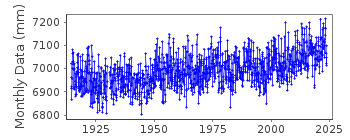
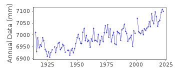
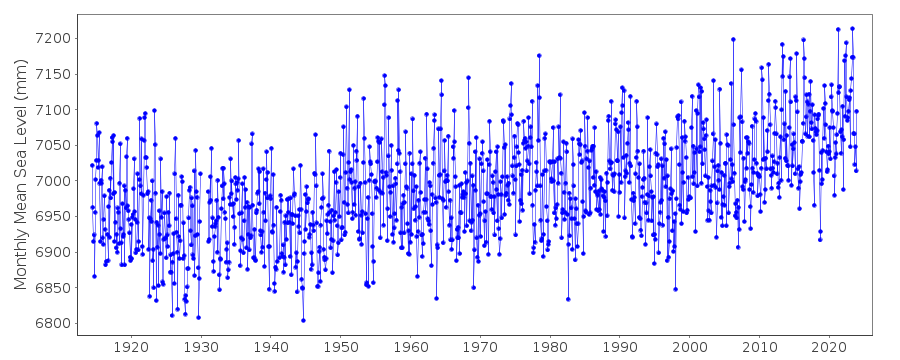
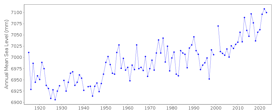
| Time span of data: | 1914 – 2025 |
| Completeness (%): | 97 |
| Date of last update: | 20 Mar 2025 |
| Green Arrow: | Current Station |
| Yellow Marker: | Neighbouring RLR Station |
| Red Marker: | Neighbouring Metric Station |
Please note: In many cases, the station position in our database is accurate to only one minute. Thus, the tide gauge may not appear to be on the coast.
Tide Gauge Data
Additional Data Sources (guide to additional data sources)
Nearby GNSS Stations from SONEL: CHIP, SYDN, UNSW, FTDNFast Delivery Data from UHSLC station 333: hourly and daily
Research Quality Data from UHSLC station 333: hourly and daily
Station Documentation
Link to RLR information.Documentation added 1995-05-02
Station density along some sections of the Australian coast has meant that station codes 601 onwards have been re-ordered compared to those in earlier versions of the PSMSL data set.Documentation added 2002-01-10
Sydney, F.Denison 2 680/140 RLR(1972,FD) is 12.7m below PM 101Documentation added 2002-01-10
Data in this Sydney, Fort Denison record are true MSL (from hourly values) unlike the MTL of record id.65. The analogue tide gauge was replaced by an acoustic digital gauge in 1996.Documentation added 2013-01-08
From documentation downloaded from NTC primary benchmark is confirmed as PM 101 (Dept. of Lands) a brass plug 6.647m above datum. There are two sensors at site both SONIC WATER LEVEL SENSORS and both Model SR-10Documentation added 2019-06-06
2018 data replaced - previous version was loaded in error. That data was not from Fort Denison, but from a gauge in a nearby naval base.Data Authority
National Tidal CentreBureau of Meteorology
PO Box 421
Kent Town 5071
South Australia
Documentation added 2010-08-12
Formerly known as the National Tidal Facility

![]()
![]()
![]()
