Data
- Obtaining
- Supplying
- High-Frequency
- Bottom Pressure Records
- Other Long Records
- GLOSS/ODINAFRICA Calibration Data
Donate
Donate to PSMSL
Data Notes
- Individual Station Data and Plot Notes
- Referencing the Data Set
- PSMSL Help File
- 2010 Changes to the PSMSL Data Files
Extracted from Database
13 Jul 2026
Station Information
| Station ID: | 2010 |
| Latitude: | 40.966667 |
| Longitude: | 27.966667 |
| Coastline code: | 310 |
| Station code: | 37 |
| Country: | TÜRKİYE |
| Time span of data: | 2004 – 2009 |
| Completeness (%): | 79 |
| Date of last update: | 28 Jun 2010 |
| Green Arrow: | Current Station |
| Yellow Marker: | Neighbouring RLR Station |
| Red Marker: | Neighbouring Metric Station |
Please note: In many cases, the station position in our database is accurate to only one minute. Thus, the tide gauge may not appear to be on the coast.
Tide Gauge Data
Additional Data Sources (guide to additional data sources)
Nearby Real Time Stations from VLIZ: maerStation Documentation
Link to RLR information.Documentation added 2010-06-28
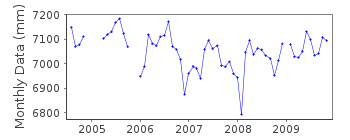
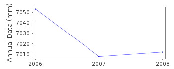
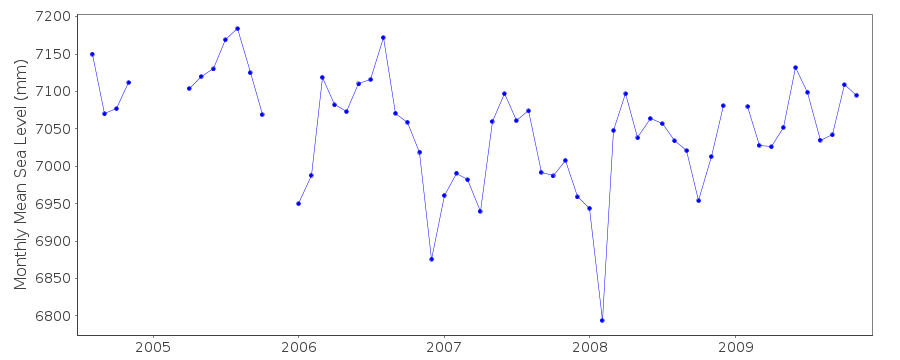
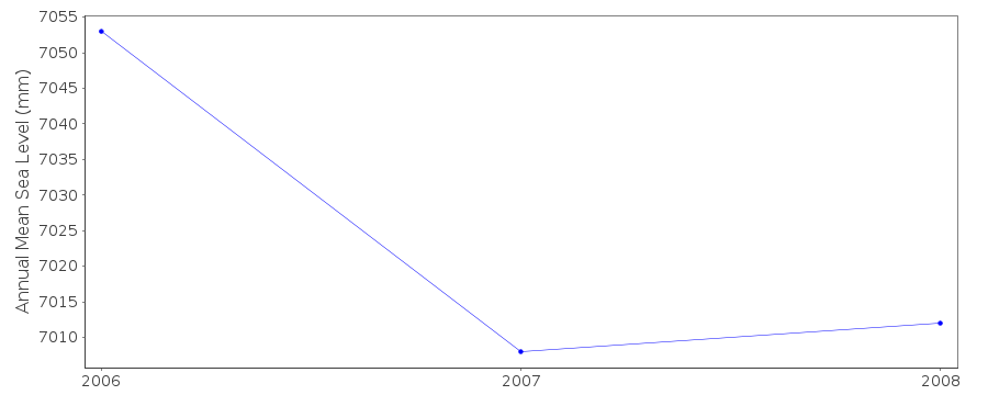
Marmara Ereglisi is on the Sea of Marmara. This station forms part of theTurkish Sea Level Monitoring Network. Coast/Station code 310/037 id=2010.
Total dataset was revised by the authority and this station was created RLR.
RLR (2008) is 8.700m below TGBM MERG-1. RLR factor is 5.673m.
Data Authority
General Directorate of MappingTlp Fakultesi Cad
06590 Cebeci/Cankaya
Ankara

![]()
![]()
![]()
