Data
- Obtaining
- Supplying
- High-Frequency
- Bottom Pressure Records
- Other Long Records
- GLOSS/ODINAFRICA Calibration Data
Donate
Donate to PSMSL
Data Notes
- Individual Station Data and Plot Notes
- Referencing the Data Set
- PSMSL Help File
- 2010 Changes to the PSMSL Data Files
Extracted from Database
20 Jul 2026
Station Information
| Station ID: | 2012 |
| Latitude: | 5.284333 |
| Longitude: | -52.5865 |
| GLOSS ID: | 202 |
| Coastline code: | 876 |
| Station code: | 11 |
| Country: | FRENCH GUIANA |
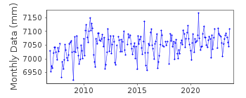
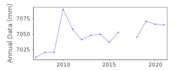
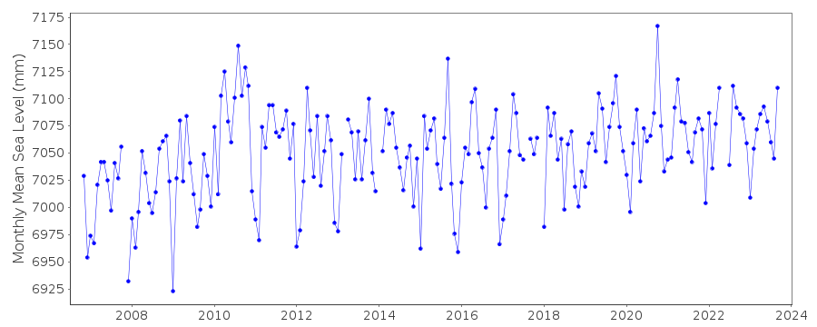
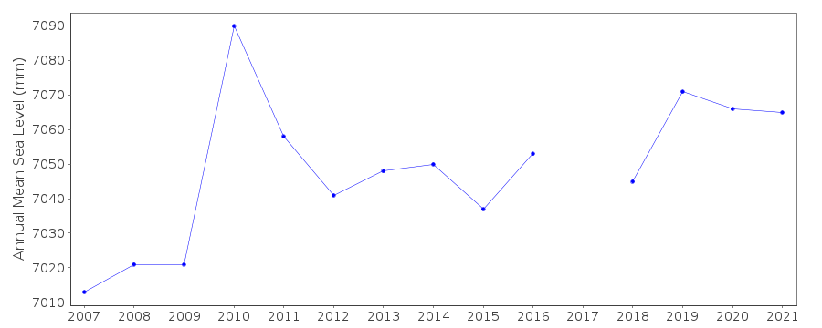
| Time span of data: | 1989 – 2025 |
| Completeness (%): | 49 |
| Link to ellipsoid: | Available |
| Date of last update: | 20 Feb 2026 |
| Green Arrow: | Current Station |
| Yellow Marker: | Neighbouring RLR Station |
| Red Marker: | Neighbouring Metric Station |
Please note: In many cases, the station position in our database is accurate to only one minute. Thus, the tide gauge may not appear to be on the coast.
Tide Gauge Data
Additional Data Sources (guide to additional data sources)
Nearby GNSS Stations from SONEL: IRYL, IROYResearch Quality Data from UHSLC station 851: hourly and daily
Research Quality Data from UHSLC station 850: hourly and daily
Station Documentation
Link to RLR information.Documentation added 2010-05-18
New station Iles du Salut French Guiana. Country/station code 876/011.TGBM is benchmark 'A' 6.884m above TGZ.Documentation added 2014-02-11
Whole dataset has been re-loaded from SONEL. Several datapoints have been revised/added.Documentation added 2015-11-05
This station was previously known as Iles du Salut the collective name for the three islands off French Guiana. This has now been changed to Ile Royale the name of the island on which the tide gauge is situated.Documentation added 2016-06-22
While adding the 2015 data to the dataset it was noted that values for April-September 2012 had been revised.Documentation added 2025-07-15
Updated the whole dataset to ensure they include all the historical data recovered recently by SHOM and the calculated monthly and annual means match those distributed by SONEL.Data Authority
SHOM13 rue de Chatelier
29200 BREST

![]()
![]()
![]()
