Data
- Obtaining
- Supplying
- High-Frequency
- Bottom Pressure Records
- Other Long Records
- GLOSS/ODINAFRICA Calibration Data
Donate
Donate to PSMSL
Data Notes
- Individual Station Data and Plot Notes
- Referencing the Data Set
- PSMSL Help File
- 2010 Changes to the PSMSL Data Files
Extracted from Database
13 Jul 2026
Station Information
| Station ID: | 2031 |
| Latitude: | 47.378861 |
| Longitude: | -61.857306 |
| Coastline code: | 970 |
| Station code: | 30 |
| Country: | CANADA |
| Time span of RLR data: | 2007 – 2024 |
| RLR completeness (%): | 93 |
| Time span of metric data: | 1964 – 2024 |
| Metric completeness (%): | 44 |
| Date of last update: | 19 Jun 2025 |
| Green Arrow: | Current Station |
| Yellow Marker: | Neighbouring RLR Station |
| Red Marker: | Neighbouring Metric Station |
Please note: In many cases, the station position in our database is accurate to only one minute. Thus, the tide gauge may not appear to be on the coast.
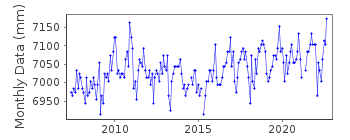
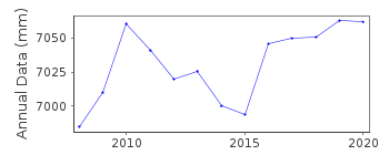
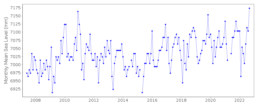
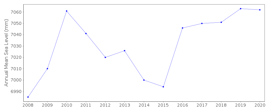
Tide Gauge Data
Station Documentation
Link to RLR information.Documentation added 2010-08-10
This is a new station on the Iles de la Madeleine in the Gulf of St. Lawrence.It is the permanent gauge replacement for Ile d'Entree.
Documentation added 2011-09-06
Station has been made RLR. Primary benchmark is 79KZ130 3.206m above TGZ. RLRyear is 2008 and RLR factor 6.094m.
Documentation added 2015-07-27
This year, rather than just sending the latest year of data, the complete dataset has been supplied. This has highlighted some differences in the data. From communications in the correspondence file for 2002 it appears that the Oceans and Fisheries meant to supply revised data for the stations supplied. This did not happen. The complete dataset includes these data revisions. Therefore, the whole dataset has now been re-entered.Documentation added 2015-07-30
Historic data was included in the above complete dataset. The datum for the period 1964-2001 is currently being queried. Until the Fisheries and Oceans Canada confirm the datum this data has been made Metric.Documentation added 2016-08-17
From benchmark information from the Fisheries and Oceans Canada website the datum on the RLR diagram has been changed to read Chart Datum (CD)Data Authority
Canadian Hydrographic Service615 Booth Street
Ottawa
Ontario K1A 0E6

![]()
![]()
![]()
