Data
- Obtaining
- Supplying
- High-Frequency
- Bottom Pressure Records
- Other Long Records
- GLOSS/ODINAFRICA Calibration Data
Donate
Donate to PSMSL
Data Notes
- Individual Station Data and Plot Notes
- Referencing the Data Set
- PSMSL Help File
- 2010 Changes to the PSMSL Data Files
Extracted from Database
13 Jul 2026
Station Information
| Station ID: | 2051 |
| Latitude: | 27.784108 |
| Longitude: | -17.901611 |
| Coastline code: | 370 |
| Station code: | 9 |
| Country: | SPAIN |
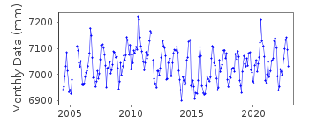
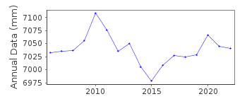
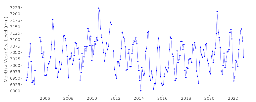
| Time span of data: | 2004 – 2024 |
| Completeness (%): | 96 |
| Date of last update: | 03 Jul 2025 |
| Green Arrow: | Current Station |
| Yellow Marker: | Neighbouring RLR Station |
| Red Marker: | Neighbouring Metric Station |
Please note: In many cases, the station position in our database is accurate to only one minute. Thus, the tide gauge may not appear to be on the coast.
Tide Gauge Data
Additional Data Sources (guide to additional data sources)
Nearby GNSS Stations from SONEL: FRON, EH01Nearby Real Time Stations from VLIZ: hie2
Station Documentation
Link to RLR information.Documentation added 2011-01-24
This is a new station first data 2009. Data has previously been supplied but latitude andlongitude only now confirmed. Benchmark HI1 4.342m relative to datum REDMAR
Station made RLR. RLR year 2006 factor 5.458m.
Documentation added 2013-03-18
The Aanderra pressure gauge at Hierro has been moved and replaced by a new MIROSradar sensor. Both old and new gauges were operating for the period 14.11.2009-
15.06.2010 for inter-comparison purposes. During this period a bias (mean difference) between the two
gauges was calculated as -0.29cm. A malfunction in the old sensor was also detected.
There was also a datum change of -9cm from Nov. 2011.
See B. Perez et al paper 'Overlapping sea level time series
measured using different technologies: an example from the REDMAR Spanish
network'.
Documentation added 2014-01-13
Further investigation revealed that the bias was due to a fault in the old Pressure gauge. Data from this was revised. Complete dataset was re-entered into database.Documentation added 2014-04-28
At the request of Puerto del Estado the latitude and longitude have been changed from 27.800000 -17.898333 derived from the previously supplied degrees and minutes value to 27.78408 -17.90163 which is the position of the new MIROS gauge in decimal degrees.Data Authority
Puertos del EstadoÁrea de Conocimiento y Análisis del Medio Físico
Avda. Del Partenón, 10
28042, Madrid
Documentation added 2001-03-06
The Area de Conocimiento y Analisis del Medio Fisico wasformerly known as the Departamento de Clima Maritimo.

![]()
![]()
![]()
