Data
- Obtaining
- Supplying
- High-Frequency
- Bottom Pressure Records
- Other Long Records
- GLOSS/ODINAFRICA Calibration Data
Donate
Donate to PSMSL
Data Notes
- Individual Station Data and Plot Notes
- Referencing the Data Set
- PSMSL Help File
- 2010 Changes to the PSMSL Data Files
Extracted from Database
13 Jul 2026
Station Information
| Station ID: | 2071 |
| Latitude: | -41.064444 |
| Longitude: | 146.794722 |
| Coastline code: | 680 |
| Station code: | 194 |
| Country: | AUSTRALIA |
| Time span of RLR data: | 2010 – 2024 |
| RLR completeness (%): | 92 |
| Time span of metric data: | 2003 – 2024 |
| Metric completeness (%): | 82 |
| Date of last update: | 01 Jun 2026 |
| Green Arrow: | Current Station |
| Yellow Marker: | Neighbouring RLR Station |
| Red Marker: | Neighbouring Metric Station |
Please note: In many cases, the station position in our database is accurate to only one minute. Thus, the tide gauge may not appear to be on the coast.
Tide Gauge Data

Station Documentation
Link to RLR information.Documentation added 2011-10-18
Low Head Tasmania is a new station. Gauge zero is given as 1.852m below AHD (TAS).Documentation added 2016-07-07
Using information form the NTC website Low Head has been made RLR. Primary benchmark is SPM 9214 3.861m above the gauge datum.Documentation added 2018-10-03
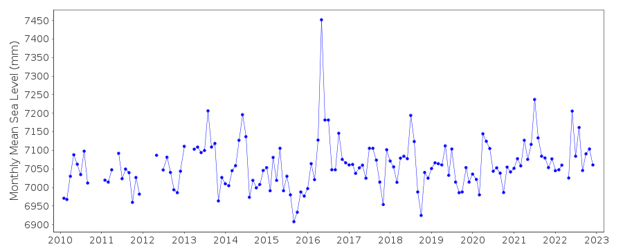
Three Tasmanian stations Burnie, Devonport and Low Head have a spike in May 2016. When these are plotted together the spike gets larger as it travels around the coastline from Burnie to Devonport and finally to Low Head where the spike is so great it looks like an anomaly.Documentation added 2021-02-07
Latest data available for download from NTC for station Low Head is that for 2019.Data Authority
National Tidal CentreBureau of Meteorology
PO Box 421
Kent Town 5071
South Australia
Documentation added 2010-08-12
Formerly known as the National Tidal Facility

![]()
![]()
![]()
