Data
- Obtaining
- Supplying
- High-Frequency
- Bottom Pressure Records
- Other Long Records
- GLOSS/ODINAFRICA Calibration Data
Donate
Donate to PSMSL
Data Notes
- Individual Station Data and Plot Notes
- Referencing the Data Set
- PSMSL Help File
- 2010 Changes to the PSMSL Data Files
Extracted from Database
13 Jul 2026
Station Information
| Station ID: | 2074 |
| Latitude: | -20.016667 |
| Longitude: | 148.25 |
| Coastline code: | 680 |
| Station code: | 50 |
| Country: | AUSTRALIA |
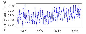
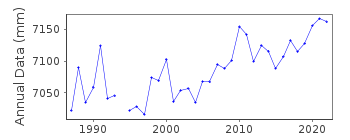
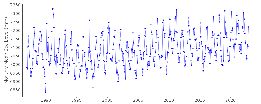
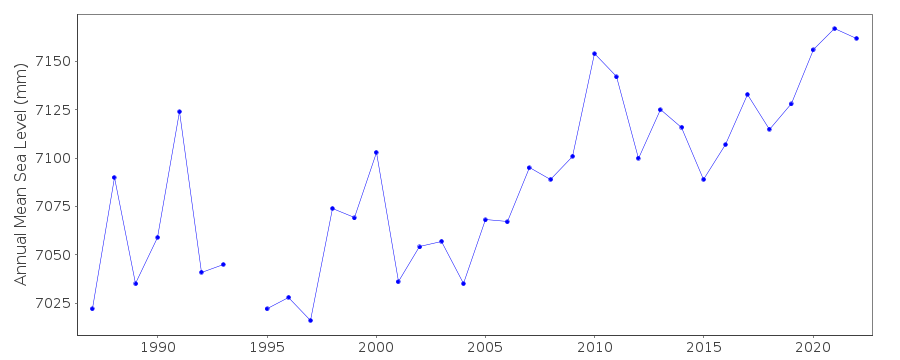
| Time span of data: | 1986 – 2024 |
| Completeness (%): | 97 |
| Date of last update: | 01 Jun 2026 |
| Green Arrow: | Current Station |
| Yellow Marker: | Neighbouring RLR Station |
| Red Marker: | Neighbouring Metric Station |
Please note: In many cases, the station position in our database is accurate to only one minute. Thus, the tide gauge may not appear to be on the coast.
Tide Gauge Data
Station Documentation
Link to RLR information.Documentation added 2011-10-18
Bowen II is a new station to PSMSL although data exists for Bowen id.676 for Oct.1951-Sept.1953. Data was downloaded from the National Tidal Centre,Australia. Dataset starts in Dec.1986. Because metadata was also available for this station we were ablLatest date to make it RLR. Datum referred to is Lowest Astronomical Tide (LAT). Benchmark is PSM 10009 8.689m above LAT.RLR factor is 5.311m.Documentation added 2021-02-07
Latest data available for download from the NTC for station Bowen II is that for 2019.Data Authority
National Tidal CentreBureau of Meteorology
PO Box 421
Kent Town 5071
South Australia
Documentation added 2010-08-12
Formerly known as the National Tidal Facility

![]()
![]()
![]()
