Data
- Obtaining
- Supplying
- High-Frequency
- Bottom Pressure Records
- Other Long Records
- GLOSS/ODINAFRICA Calibration Data
Donate
Donate to PSMSL
Data Notes
- Individual Station Data and Plot Notes
- Referencing the Data Set
- PSMSL Help File
- 2010 Changes to the PSMSL Data Files
Extracted from Database
13 Jul 2026
Station Information
| Station ID: | 2144 |
| Latitude: | 44.6779 |
| Longitude: | 12.2494 |
| Coastline code: | 270 |
| Station code: | 37 |
| Country: | ITALY |
| Time span of data: | 2009 – 2025 |
| Completeness (%): | 97 |
| Link to ellipsoid: | Available |
| Date of last update: | 15 Jun 2026 |
| Green Arrow: | Current Station |
| Yellow Marker: | Neighbouring RLR Station |
| Red Marker: | Neighbouring Metric Station |
Please note: In many cases, the station position in our database is accurate to only one minute. Thus, the tide gauge may not appear to be on the coast.
Tide Gauge Data
Station Documentation
Link to RLR information.Documentation added 2012-05-10
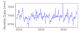
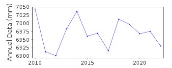
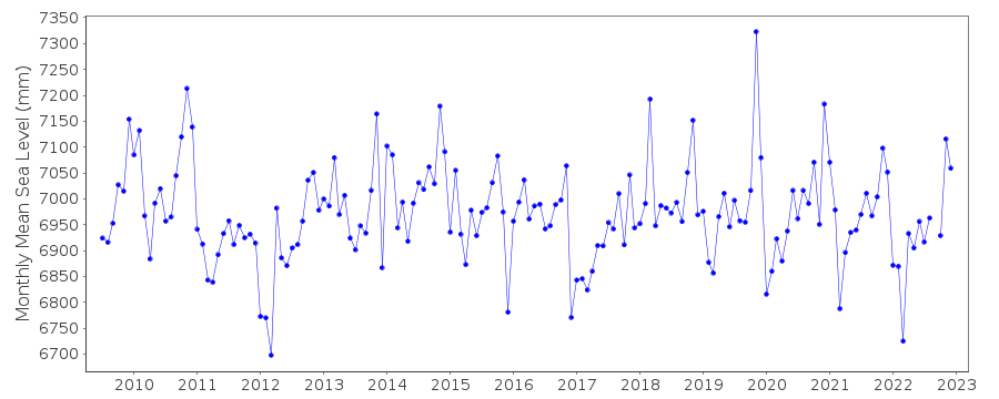
Porto Garibaldi , Comacchio, Ferrara - Italy is a new station. The monthly meansea level data values have been supplied by Alberto Pellegrinelli from the
University of Ferrara. Primary benchmark is TGBM0 3.538m above Tide Gauge Zero
(TGZ). Also at the tide gauge is benchmark 0169#-###-38# referenced as 1.946m
above the Italian National Datum System IGM. Station has now been made RLR with
factor 6.863m.
Data Authority
ARPAERegional Agency for Prevention, Environment and Energy of Emilia_Romagna
Via Po 5 - 40139
Bologna
Italy

![]()
![]()
![]()
