Data
- Obtaining
- Supplying
- High-Frequency
- Bottom Pressure Records
- Other Long Records
- GLOSS/ODINAFRICA Calibration Data
Donate
Donate to PSMSL
Data Notes
- Individual Station Data and Plot Notes
- Referencing the Data Set
- PSMSL Help File
- 2010 Changes to the PSMSL Data Files
Extracted from Database
13 Jul 2026
Station Information
| Station ID: | 2184 |
| Latitude: | 6.766667 |
| Longitude: | 73.173333 |
| Coastline code: | 454 |
| Station code: | 31 |
| Country: | MALDIVES |
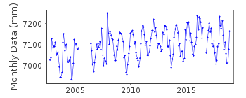
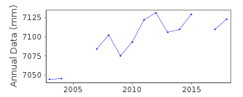
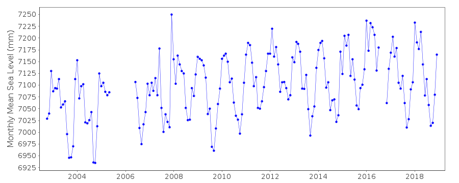
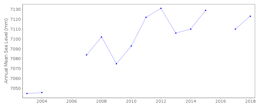
| Time span of data: | 2002 – 2018 |
| Completeness (%): | 88 |
| Date of last update: | 07 Mar 2023 |
| Green Arrow: | Current Station |
| Yellow Marker: | Neighbouring RLR Station |
| Red Marker: | Neighbouring Metric Station |
Please note: In many cases, the station position in our database is accurate to only one minute. Thus, the tide gauge may not appear to be on the coast.
Tide Gauge Data
Additional Data Sources (guide to additional data sources)
Nearby Real Time Stations from VLIZ: haniFast Delivery Data from UHSLC station 117: hourly and daily
Research Quality Data from UHSLC station 117: hourly and daily
Station Documentation
Link to RLR information.Documentation added 2014-01-16
This dataset was originally entered onto id. 1779 Hanimaadoo A but Hanimaadoo B it is a completely different gauge which hasn't been levelled into the previous gauge. Data is from a UHSLC pressure transducer gauge. 4 sensors:1. Pressure transducer (PRS)
2. Radar (RAD) (Vega Vegapuls 62)
3. Backup pressure transducer PR2
4. Radar (RA2) Sutron RLR
Documentation added 2015-11-03
Complete UHSLC updated dataset 2002-2014 loaded.Data Authority
University of Hawaii Sea Level CenterDepartment of Oceanography Division of Natural Sciences
1000 Pope Road
Honolulu
Hawaii 96822

![]()
![]()
![]()
