Data
- Obtaining
- Supplying
- High-Frequency
- Bottom Pressure Records
- Other Long Records
- GLOSS/ODINAFRICA Calibration Data
Donate
Donate to PSMSL
Data Notes
- Individual Station Data and Plot Notes
- Referencing the Data Set
- PSMSL Help File
- 2010 Changes to the PSMSL Data Files
Extracted from Database
13 Jul 2026
Station Information
| Station ID: | 2286 |
| Latitude: | 23.020833 |
| Longitude: | -82.755833 |
| Coastline code: | 930 |
| Station code: | 23 |
| Country: | CUBA |
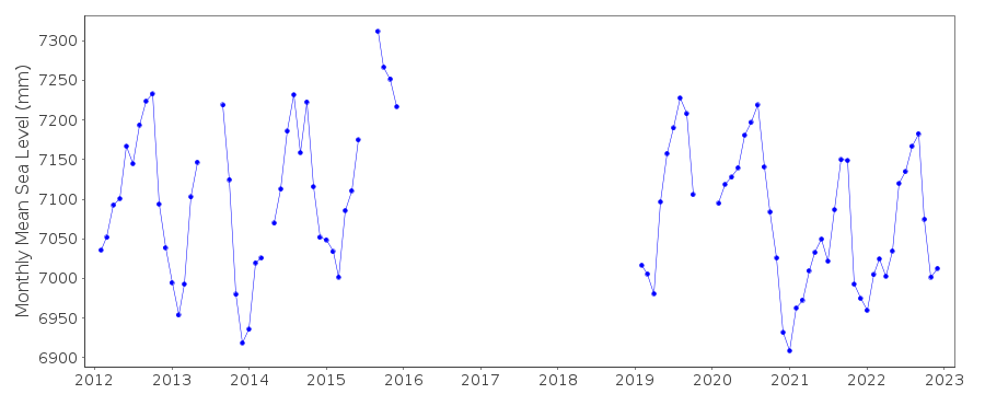
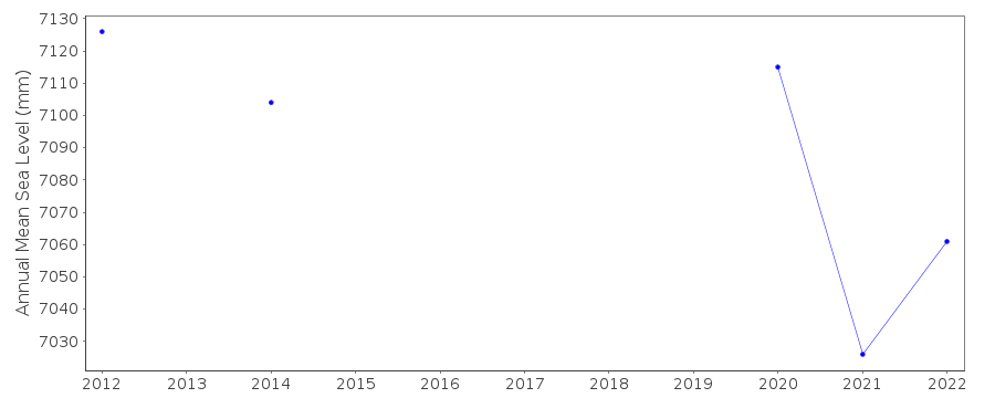
| Time span of data: | 2012 – 2024 |
| Completeness (%): | 70 |
| Date of last update: | 18 Jul 2025 |
| Green Arrow: | Current Station |
| Yellow Marker: | Neighbouring RLR Station |
| Red Marker: | Neighbouring Metric Station |
Please note: In many cases, the station position in our database is accurate to only one minute. Thus, the tide gauge may not appear to be on the coast.
Tide Gauge Data

Station Documentation
Link to RLR information.Documentation added 2016-02-25
Mariel Boca is a newly supplied Cuban station. Using information supplied by the Cuban National Tidal Service Mariel Boca has been made RLR. Primary benchmark is TGBM ICH-256 3.404m above the Tide Gauge Zero (TGZ) and 2.764m above the Geodesic National Datum (GND).Documentation added 2016-06-29
Using recent information supplied by Cuba the tide gauge sensors are from 1999 a float recording hourly and from 2013 a pressure sensor with 6 minute frequency.Documentation added 2018-03-20
The PSMSL has been notified that the tide gauge at Mariel is currently out of serviceDocumentation added 2021-09-24
The Mariel station was destroyed by a local storm in 2016. The dock where the tide gauge was located was seriously damaged. The station was reinstalled in 2019 to a nearby dock.Data Authority
Cuban National Tidal ServiceCalle 4 No. 304, E/3 Y 3-a
Playa
Cuidad Habana

![]()
![]()
![]()
